Weissenbach am Lech geodata
Weissenbach am Lech (Tyrol) is a populated place; located in Austria in Europe/Vienna (GMT+2) time zone. With population of 1,231 people, there are 1022 cities with bigger population in this country. Compared to other cities in Austria, 57.2% of cities are located further ↑North; 95.3% of cities are located further →East and 90% of cities have lower elevation than Weissenbach am Lech. Note1
Administrative division(s):
- Level 1: Tyrol
- Level 2: Politischer Bezirk Reutte
- Level 3: Weißenbach am Lech


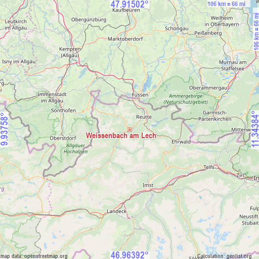
Weissenbach am Lech GPS coordinates[2]
47° 26' 29.832" North, 10° 38' 26.556" East
| Map corner | latitude | longitude |
|---|---|---|
| Upper-left | 47.91502°, | 9.93758° |
| Center: | 47.44162°, | 10.64071° |
| Lower-right: | 46.96392°, | 11.34384° |
| Map W x H: | 105.8×105.8 km | = 65.7×65.7mi |
| max Lat: | 48.98333° ⇑57.2% North |
| Weissenbach am Lech: | 47.44162° |
| min Lat: | ⇓42.8% South 46.48841° |
| min Long | Weissenbach am | max Long |
| 9.57802° | 10.64071° | 17.1° |
| W 4.7%⇐ | ⇒95.3% E |
Elevation
Elevation of Weissenbach am Lech is 882 m = 2894 ft, and this is 376.5 m = 1235 ft above average elevation for this country.
| Max E: |
2140 m = 7021 ft | 10% |
| Weissenbach am Lech | 882 m 2894 ft | |
| Avg. | 505.5 m = 1658 ft | |
Min E: |
118 m = 387 ft | 90% |
See also: Austria elevation on elevation.city.
Geographical zone
Weissenbach am Lech is located in North temperate zone (between Tropic of Cancer and the Arctic Circle). Distance of this North polar circle is 2126.2 km =1321.2 mi to North.| Distance of | km | miles | from Weissenbach am Lech |
|---|---|---|---|
| North Pole | 4732 | 2940.3 | to North |
| Arctic Circle | 2126.2 | 1321.2 | to North |
| Tropic Cancer | 2669.1 | 1658.5 | to South |
| Equator | 5275 | 3277.7 | to South |


Nearby cities:
15 places around Weissenbach am Lech: (largest is in red/bold)
• Berwang
8.8 km =5.5 mi,  114°
114°
• Breitenwang
8.7 km =5.4 mi,  54°
54°
• Ehenbichl
5.3 km =3.3 mi,  58°
58°
• Forchach
5.1 km =3.2 mi,  237°
237°
• Grän
9.4 km =5.8 mi,  313°
313°
• Heiterwang
8.3 km =5.2 mi,  83°
83°
• Höfen
4.2 km =2.6 mi, 49°
• Lechaschau
7.1 km =4.4 mi,  43°
43°
• Musau
10.3 km =6.4 mi,  13°
13°
• Namlos
10.4 km =6.5 mi,  169°
169°
• Nesselwängle
5 km =3.1 mi,  338°
338°
• Pflach
10.1 km =6.3 mi,  34°
34°
• Reutte
7.4 km =4.6 mi, 50°
• Stanzach
8.5 km =5.3 mi,  220°
220°
• Wängle
6.2 km =3.9 mi, 36°
Sources, notices
• [Note1] Compared only with cities in Austria existing in our database
• [Src1] Map data: © OpenStreetMap contributors (CC-BY-SA)
• [Src2] Other city data from geonames.org with taken over terms of usage.
• [Src3] Geographical zone / Annual Mean Temperature by Robert A. Rohde @ Wikipedia
