Weissach geodata
Weissach (Tyrol) is a populated place; located in Austria in Europe/Vienna (GMT+2) time zone. With population of 2,047 people, there are 598 cities with bigger population in this country. Compared to other cities in Austria, 50.7% of cities are located further ↑North; 87.8% of cities are located further →East and 57.1% of cities have lower elevation than Weissach. Note1


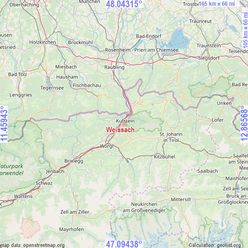
Weissach GPS coordinates[2]
47° 34' 15.276" North, 12° 9' 45.18" East
| Map corner | latitude | longitude |
|---|---|---|
| Upper-left | 48.04315°, | 11.45943° |
| Center: | 47.57091°, | 12.16255° |
| Lower-right: | 47.09438°, | 12.86568° |
| Map W x H: | 105.5×105.5 km | = 65.6×65.6mi |
| max Lat: | 48.98333° ⇑50.7% North |
| Weissach: | 47.57091° |
| min Lat: | ⇓49.3% South 46.48841° |
| min Long | Weissach | max Long |
| 9.57802° | 12.16255° | 17.1° |
| W 12.2%⇐ | ⇒87.8% E |
Elevation
Elevation of Weissach is 499 m = 1637 ft, and this is 6.5 m = 21 ft below average elevation for this country.
| Max E: |
2140 m = 7021 ft | 42.9% |
| Avg. | 505.5 m = 1658 ft | |
| Weissach | 499 m = 1637 ft | |
Min E: |
118 m = 387 ft | 57.1% |
See also: Austria elevation on elevation.city.
Geographical zone
Weissach is located in North temperate zone (between Tropic of Cancer and the Arctic Circle). Distance of this North polar circle is 2111.8 km =1312.2 mi to North.| Distance of | km | miles | from Weissach |
|---|---|---|---|
| North Pole | 4717.7 | 2931.4 | to North |
| Arctic Circle | 2111.8 | 1312.2 | to North |
| Tropic Cancer | 2683.5 | 1667.4 | to South |
| Equator | 5289.4 | 3286.7 | to South |


Nearby cities:
15 places around Weissach: (largest is in red/bold)
• Bad Häring
7.4 km =4.6 mi,  205°
205°
• Eichelwang
3.6 km =2.2 mi,  29°
29°
• Endach
0.6 km =0.4 mi,  236°
236°
• Hinterthiersee
7.3 km =4.5 mi,  280°
280°
• Kufstein
1.4 km =0.9 mi,  12°
12°
• Langkampfen
5.2 km =3.2 mi, 241°
• Mitterland
5.3 km =3.3 mi,  289°
289°
• Mitterndorf
0.9 km =0.6 mi,  37°
37°
• Niederbreitenbach
7.3 km =4.5 mi,  234°
234°
• Oberndorf
6.5 km =4 mi, 38°
• Schwoich
3.2 km =2 mi, 210°
• Thiersee
4.3 km =2.7 mi,  307°
307°
• Unterlangkampfen
5.2 km =3.2 mi, 243°
• Vorderthiersee
4.9 km =3 mi, 286°
• Zell
1.7 km =1.1 mi,  325°
325°
Sources, notices
• [Note1] Compared only with cities in Austria existing in our database
• [Src1] Map data: © OpenStreetMap contributors (CC-BY-SA)
• [Src2] Other city data from geonames.org with taken over terms of usage.
• [Src3] Geographical zone / Annual Mean Temperature by Robert A. Rohde @ Wikipedia
