Niederbreitenbach geodata
Niederbreitenbach (Tyrol) is a populated place; located in Austria in Europe/Vienna (GMT+2) time zone. With population of 1,132 people, there are 1123 cities with bigger population in this country. Compared to other cities in Austria, 52.3% of cities are located further ↑North; 88.4% of cities are located further →East and 57.7% of cities have lower elevation than Niederbreitenbach. Note1
Administrative division(s):
- Level 1: Tyrol
- Level 2: Politischer Bezirk Kufstein
- Level 3: Langkampfen


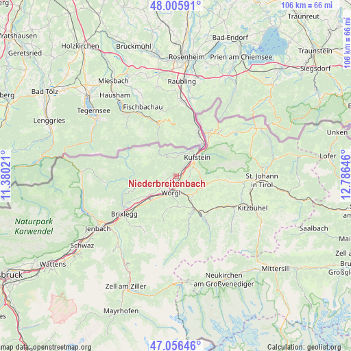
Niederbreitenbach GPS coordinates[2]
47° 31' 59.988" North, 12° 4' 59.988" East
| Map corner | latitude | longitude |
|---|---|---|
| Upper-left | 48.00591°, | 11.38021° |
| Center: | 47.53333°, | 12.08333° |
| Lower-right: | 47.05646°, | 12.78646° |
| Map W x H: | 105.6×105.6 km | = 65.6×65.6mi |
| max Lat: | 48.98333° ⇑52.3% North |
| Niederbreitenbach: | 47.53333° |
| min Lat: | ⇓47.7% South 46.48841° |
| min Long | Niederbreitenba | max Long |
| 9.57802° | 12.08333° | 17.1° |
| W 11.6%⇐ | ⇒88.4% E |
Elevation
Elevation of Niederbreitenbach is 503 m = 1650 ft, and this is 2.5 m = 8 ft below average elevation for this country.
| Max E: |
2140 m = 7021 ft | 42.3% |
| Avg. | 505.5 m = 1658 ft | |
| Niederbreitenbach | 503 m = 1650 ft | |
Min E: |
118 m = 387 ft | 57.7% |
See also: Austria elevation on elevation.city.
Geographical zone
Niederbreitenbach is located in North temperate zone (between Tropic of Cancer and the Arctic Circle). Distance of this North polar circle is 2116 km =1314.8 mi to North.| Distance of | km | miles | from Niederbreitenbach |
|---|---|---|---|
| North Pole | 4721.9 | 2934.1 | to North |
| Arctic Circle | 2116 | 1314.8 | to North |
| Tropic Cancer | 2679.3 | 1664.8 | to South |
| Equator | 5285.2 | 3284.1 | to South |


Nearby cities:
15 places around Niederbreitenbach: (largest is in red/bold)
• Angath
3.2 km =2 mi,  205°
205°
• Angerberg
5 km =3.1 mi,  231°
231°
• Bad Häring
3.7 km =2.3 mi,  133°
133°
• Endach
6.7 km =4.2 mi,  54°
54°
• Hinterthiersee
5.7 km =3.5 mi,  347°
347°
• Kirchbichl
2 km =1.2 mi,  151°
151°
• Langkampfen
2.2 km =1.4 mi,  38°
38°
• Mariastein
2.2 km =1.4 mi,  253°
253°
• Mitterland
6 km =3.7 mi,  9°
9°
• Oberlangkampfen
1.4 km =0.9 mi,  163°
163°
• Schwoich
4.5 km =2.8 mi,  71°
71°
• Thiersee
7.2 km =4.5 mi,  20°
20°
• Unterlangkampfen
2.2 km =1.4 mi,  34°
34°
• Vorderthiersee
5.7 km =3.5 mi, 12°
• Wörgl
5.2 km =3.2 mi,  198°
198°
Sources, notices
• [Note1] Compared only with cities in Austria existing in our database
• [Src1] Map data: © OpenStreetMap contributors (CC-BY-SA)
• [Src2] Other city data from geonames.org with taken over terms of usage.
• [Src3] Geographical zone / Annual Mean Temperature by Robert A. Rohde @ Wikipedia
