Untertauern geodata
Untertauern (Salzburg) is a seat of a third-order administrative division; located in Austria in Europe/Vienna (GMT+2) time zone. With population of 257 people, there are 2799 cities with bigger population in this country. Compared to other cities in Austria, 65.5% of cities are located further ↑North; 74.8% of cities are located further →East and 97.7% of cities have lower elevation than Untertauern. Note1
Administrative division(s):
- Level 1: Salzburg
- Level 2: Politischer Bezirk Sankt Johann im Pongau
- Level 3: Untertauern


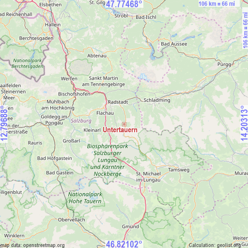
Untertauern GPS coordinates[2]
47° 18' 0" North, 13° 30' 0" East
| Map corner | latitude | longitude |
|---|---|---|
| Upper-left | 47.77468°, | 12.79688° |
| Center: | 47.3°, | 13.5° |
| Lower-right: | 46.82102°, | 14.20313° |
| Map W x H: | 106×106 km | = 65.9×65.9mi |
| max Lat: | 48.98333° ⇑65.5% North |
| Untertauern: | 47.3° |
| min Lat: | ⇓34.5% South 46.48841° |
| min Long | Untertauern | max Long |
| 9.57802° | 13.5° | 17.1° |
| W 25.2%⇐ | ⇒74.8% E |
Elevation
Elevation of Untertauern is 1166 m = 3825 ft, and this is 660.5 m = 2167 ft above average elevation for this country.
| Max E: |
2140 m = 7021 ft | 2.3% |
| Untertauern | 1166 m 3825 ft | |
| Avg. | 505.5 m = 1658 ft | |
Min E: |
118 m = 387 ft | 97.7% |
See also: Austria elevation on elevation.city.
Geographical zone
Untertauern is located in North temperate zone (between Tropic of Cancer and the Arctic Circle). Distance of this North polar circle is 2141.9 km =1330.9 mi to North.| Distance of | km | miles | from Untertauern |
|---|---|---|---|
| North Pole | 4747.8 | 2950.1 | to North |
| Arctic Circle | 2141.9 | 1330.9 | to North |
| Tropic Cancer | 2653.3 | 1648.7 | to South |
| Equator | 5259.3 | 3268 | to South |


Nearby cities:
15 places around Untertauern: (largest is in red/bold)
• Altenmarkt im Pongau
11.2 km =7 mi,  325°
325°
• Am Feuersang
10.6 km =6.6 mi,  314°
314°
• Eben im Pongau
13.4 km =8.3 mi, 325°
• Filzmoos
14.9 km =9.3 mi,  4°
4°
• Flachau
9.5 km =5.9 mi,  300°
300°
• Forstau
9.7 km =6 mi,  25°
25°
• Hof
14.9 km =9.3 mi,  291°
291°
• Hofmarkt
14.9 km =9.3 mi,  275°
275°
• Höch
11.5 km =7.1 mi, 310°
• Kleinarl
13.8 km =8.6 mi,  259°
259°
• Löbenau
9.4 km =5.8 mi,  352°
352°
• Pichl
11.9 km =7.4 mi,  39°
39°
• Radstadt
10 km =6.2 mi,  337°
337°
• Reitdorf
11.5 km =7.1 mi, 310°
• Schwemmberg
11 km =6.8 mi, 353°
Sources, notices
• [Note1] Compared only with cities in Austria existing in our database
• [Src1] Map data: © OpenStreetMap contributors (CC-BY-SA)
• [Src2] Other city data from geonames.org with taken over terms of usage.
• [Src3] Geographical zone / Annual Mean Temperature by Robert A. Rohde @ Wikipedia
