Am Feuersang geodata
Am Feuersang (Salzburg) is a populated place; located in Austria in Europe/Vienna (GMT+2) time zone. With population of 900 people, there are 1428 cities with bigger population in this country. Compared to other cities in Austria, 61.9% of cities are located further ↑North; 76.6% of cities are located further →East and 93.5% of cities have lower elevation than Am Feuersang. Note1
Administrative division(s):
- Level 1: Salzburg
- Level 2: Politischer Bezirk Sankt Johann im Pongau
- Level 3: Flachau


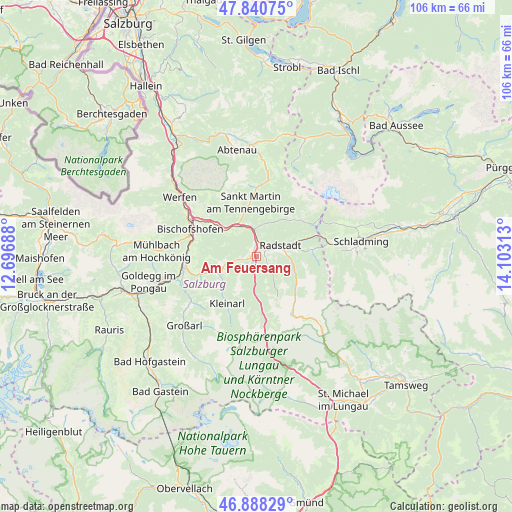
Am Feuersang GPS coordinates[2]
47° 22' 0.012" North, 13° 24' 0" East
| Map corner | latitude | longitude |
|---|---|---|
| Upper-left | 47.84075°, | 12.69688° |
| Center: | 47.36667°, | 13.4° |
| Lower-right: | 46.88829°, | 14.10313° |
| Map W x H: | 105.9×105.9 km | = 65.8×65.8mi |
| max Lat: | 48.98333° ⇑61.9% North |
| Am Feuersang: | 47.36667° |
| min Lat: | ⇓38.1% South 46.48841° |
| min Long | Am Feuersang | max Long |
| 9.57802° | 13.4° | 17.1° |
| W 23.4%⇐ | ⇒76.6% E |
Elevation
Elevation of Am Feuersang is 973 m = 3192 ft, and this is 467.5 m = 1534 ft above average elevation for this country.
| Max E: |
2140 m = 7021 ft | 6.5% |
| Am Feuersang | 973 m 3192 ft | |
| Avg. | 505.5 m = 1658 ft | |
Min E: |
118 m = 387 ft | 93.5% |
See also: Austria elevation on elevation.city.
Geographical zone
Am Feuersang is located in North temperate zone (between Tropic of Cancer and the Arctic Circle). Distance of this North polar circle is 2134.5 km =1326.3 mi to North.| Distance of | km | miles | from Am Feuersang |
|---|---|---|---|
| North Pole | 4740.4 | 2945.5 | to North |
| Arctic Circle | 2134.5 | 1326.3 | to North |
| Tropic Cancer | 2660.8 | 1653.3 | to South |
| Equator | 5266.7 | 3272.6 | to South |


Nearby cities:
15 places around Am Feuersang: (largest is in red/bold)
• Altenmarkt im Pongau
2.2 km =1.4 mi,  34°
34°
• Eben im Pongau
3.7 km =2.3 mi,  0°
0°
• Flachau
2.6 km =1.6 mi,  194°
194°
• Hof
6.5 km =4 mi,  253°
253°
• Hofmarkt
9.5 km =5.9 mi,  230°
230°
• Höch
1.3 km =0.8 mi,  270°
270°
• Hüttau
8.9 km =5.5 mi,  308°
308°
• Löbenau
6.5 km =4 mi,  73°
73°
• Radstadt
4.2 km =2.6 mi,  63°
63°
• Reitdorf
1.3 km =0.8 mi, 270°
• Schwemmberg
7.1 km =4.4 mi, 60°
• Sonnberg
8.4 km =5.2 mi, 311°
• St. Martin of Tennengebirge
11.1 km =6.9 mi,  351°
351°
• Untertauern
10.6 km =6.6 mi,  134°
134°
• Wagrain
8.4 km =5.2 mi, 245°
Sources, notices
• [Note1] Compared only with cities in Austria existing in our database
• [Src1] Map data: © OpenStreetMap contributors (CC-BY-SA)
• [Src2] Other city data from geonames.org with taken over terms of usage.
• [Src3] Geographical zone / Annual Mean Temperature by Robert A. Rohde @ Wikipedia
