Tulln geodata
Tulln (Lower Austria) is a seat of a second-order administrative division; located in Austria in Europe/Vienna (GMT+2) time zone. With population of 12,421 people, there are 58 cities with bigger population in this country. Compared to other cities in Austria, 87.1% of cities are located further ↓South; 82% of cities are located further ←West and 95.5% of cities have higher elevation than Tulln. Note1
Administrative division(s):
- Level 1: Lower Austria
- Level 2: Politischer Bezirk Tulln
- Level 3: Tulln an der Donau


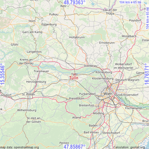
Tulln GPS coordinates[2]
48° 19' 41.844" North, 16° 3' 30.888" East
| Map corner | latitude | longitude |
|---|---|---|
| Upper-left | 48.79363°, | 15.35546° |
| Center: | 48.32829°, | 16.05858° |
| Lower-right: | 47.85867°, | 16.76171° |
| Map W x H: | 104×104 km | = 64.6×64.6mi |
| max Lat: | 48.98333° ⇑12.9% North |
| Tulln: | 48.32829° |
| min Lat: | ⇓87.1% South 46.48841° |
| min Long | Tulln | max Long |
| 9.57802° | 16.05858° | 17.1° |
| W 82%⇐ | ⇒18% E |
Elevation
Elevation of Tulln is 175 m = 574 ft, and this is 330.5 m = 1084 ft below average elevation for this country.
| Max E: |
2140 m = 7021 ft | 95.5% |
| Avg. | 505.5 m = 1658 ft | |
| Tulln | 175 m = 574 ft | |
Min E: |
118 m = 387 ft | 4.5% |
See also: Austria elevation on elevation.city.
Geographical zone
Tulln is located in North temperate zone (between Tropic of Cancer and the Arctic Circle). Distance of this North polar circle is 2027.6 km =1259.9 mi to North.| Distance of | km | miles | from Tulln |
|---|---|---|---|
| North Pole | 4633.5 | 2879.1 | to North |
| Arctic Circle | 2027.6 | 1259.9 | to North |
| Tropic Cancer | 2767.7 | 1719.8 | to South |
| Equator | 5373.6 | 3339 | to South |


Nearby cities:
15 places around Tulln: (largest is in red/bold)
• Baumgarten am Tullnerfeld
5.3 km =3.3 mi,  200°
200°
• Elsbach
8.5 km =5.3 mi,  184°
184°
• Goldgeben
7.5 km =4.7 mi,  35°
35°
• Hausleiten
6.8 km =4.2 mi,  26°
26°
• Judenau
6.1 km =3.8 mi,  217°
217°
• Katzelsdorf
6.1 km =3.8 mi,  142°
142°
• Königstetten
7 km =4.3 mi,  114°
114°
• Langenlebarn-Oberaigen
3.9 km =2.4 mi,  86°
86°
• Langenrohr
4.4 km =2.7 mi,  233°
233°
• Muckendorf an der Donau
7.2 km =4.5 mi, 86°
• Sieghartskirchen
8.8 km =5.5 mi, 202°
• Tulbing
6.1 km =3.8 mi,  129°
129°
• Unteraigen
5.3 km =3.3 mi, 85°
• Wilfersdorf
6.4 km =4 mi,  149°
149°
• Zeiselmauer
8.7 km =5.4 mi, 89°
Sources, notices
• [Note1] Compared only with cities in Austria existing in our database
• [Src1] Map data: © OpenStreetMap contributors (CC-BY-SA)
• [Src2] Other city data from geonames.org with taken over terms of usage.
• [Src3] Geographical zone / Annual Mean Temperature by Robert A. Rohde @ Wikipedia
