Elsbach geodata
Elsbach (Lower Austria) is a populated place; located in Austria in Europe/Vienna (GMT+2) time zone. With population of 578 people, there are 2220 cities with bigger population in this country. Compared to other cities in Austria, 83% of cities are located further ↓South; 81.4% of cities are located further ←West and 88.9% of cities have higher elevation than Elsbach. Note1
Administrative division(s):
- Level 1: Lower Austria
- Level 2: Politischer Bezirk Tulln
- Level 3: Sieghartskirchen


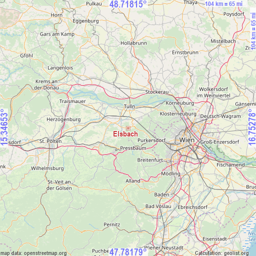
Elsbach GPS coordinates[2]
48° 15' 7.596" North, 16° 2' 58.74" East
| Map corner | latitude | longitude |
|---|---|---|
| Upper-left | 48.71815°, | 15.34653° |
| Center: | 48.25211°, | 16.04965° |
| Lower-right: | 47.78179°, | 16.75278° |
| Map W x H: | 104.1×104.1 km | = 64.7×64.7mi |
| max Lat: | 48.98333° ⇑17% North |
| Elsbach: | 48.25211° |
| min Lat: | ⇓83% South 46.48841° |
| min Long | Elsbach | max Long |
| 9.57802° | 16.04965° | 17.1° |
| W 81.4%⇐ | ⇒18.6% E |
Elevation
Elevation of Elsbach is 222 m = 728 ft, and this is 283.5 m = 930 ft below average elevation for this country.
| Max E: |
2140 m = 7021 ft | 88.9% |
| Avg. | 505.5 m = 1658 ft | |
| Elsbach | 222 m = 728 ft | |
Min E: |
118 m = 387 ft | 11.1% |
See also: Austria elevation on elevation.city.
Geographical zone
Elsbach is located in North temperate zone (between Tropic of Cancer and the Arctic Circle). Distance of this North polar circle is 2036 km =1265.1 mi to North.| Distance of | km | miles | from Elsbach |
|---|---|---|---|
| North Pole | 4641.9 | 2884.3 | to North |
| Arctic Circle | 2036 | 1265.1 | to North |
| Tropic Cancer | 2759.2 | 1714.5 | to South |
| Equator | 5365.1 | 3333.7 | to South |


Nearby cities:
15 places around Elsbach: (largest is in red/bold)
• Baumgarten am Tullnerfeld
3.7 km =2.3 mi,  340°
340°
• Gablitz
8.2 km =5.1 mi,  108°
108°
• Irenental
6.3 km =3.9 mi,  145°
145°
• Judenau
4.7 km =2.9 mi,  320°
320°
• Katzelsdorf
5.6 km =3.5 mi,  50°
50°
• Langenrohr
6.5 km =4 mi,  333°
333°
• Pressbaum
8 km =5 mi,  161°
161°
• Rekawinkel
8.3 km =5.2 mi,  193°
193°
• Riederberg
3.6 km =2.2 mi,  93°
93°
• Sieghartskirchen
2.8 km =1.7 mi,  277°
277°
• Stein
8.6 km =5.3 mi,  216°
216°
• Tulbing
7.1 km =4.4 mi, 49°
• Tulln
8.5 km =5.3 mi,  4°
4°
• Tullnerbach-Lawies
7.6 km =4.7 mi, 156°
• Wilfersdorf
4.9 km =3 mi, 52°
Sources, notices
• [Note1] Compared only with cities in Austria existing in our database
• [Src1] Map data: © OpenStreetMap contributors (CC-BY-SA)
• [Src2] Other city data from geonames.org with taken over terms of usage.
• [Src3] Geographical zone / Annual Mean Temperature by Robert A. Rohde @ Wikipedia
