Triebendorf geodata
Triebendorf (Styria) is a seat of a third-order administrative division; located in Austria in Europe/Vienna (GMT+2) time zone. With population of 2 people, there are 2957 cities with bigger population in this country. Compared to other cities in Austria, 78.3% of cities are located further ↑North; 59.8% of cities are located further →East and 89.8% of cities have lower elevation than Triebendorf. Note1


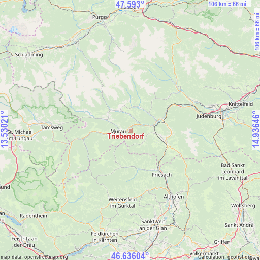
Triebendorf GPS coordinates[2]
47° 7' 0.012" North, 14° 13' 59.988" East
| Map corner | latitude | longitude |
|---|---|---|
| Upper-left | 47.593°, | 13.53021° |
| Center: | 47.11667°, | 14.23333° |
| Lower-right: | 46.63604°, | 14.93646° |
| Map W x H: | 106.4×106.4 km | = 66.1×66.1mi |
| max Lat: | 48.98333° ⇑78.3% North |
| Triebendorf: | 47.11667° |
| min Lat: | ⇓21.7% South 46.48841° |
| min Long | Triebendorf | max Long |
| 9.57802° | 14.23333° | 17.1° |
| W 40.2%⇐ | ⇒59.8% E |
Elevation
Elevation of Triebendorf is 878 m = 2881 ft, and this is 372.5 m = 1222 ft above average elevation for this country.
| Max E: |
2140 m = 7021 ft | 10.2% |
| Triebendorf | 878 m 2881 ft | |
| Avg. | 505.5 m = 1658 ft | |
Min E: |
118 m = 387 ft | 89.8% |
See also: Austria elevation on elevation.city.
Geographical zone
Triebendorf is located in North temperate zone (between Tropic of Cancer and the Arctic Circle). Distance of this North polar circle is 2162.3 km =1343.6 mi to North.| Distance of | km | miles | from Triebendorf |
|---|---|---|---|
| North Pole | 4768.2 | 2962.8 | to North |
| Arctic Circle | 2162.3 | 1343.6 | to North |
| Tropic Cancer | 2633 | 1636.1 | to South |
| Equator | 5238.9 | 3255.3 | to South |


Nearby cities:
15 places around Triebendorf: (largest is in red/bold)
• Frojach
5.9 km =3.7 mi,  74°
74°
• Katsch an der Mur
4.8 km =3 mi,  45°
45°
• Murau
4.9 km =3 mi,  262°
262°
• Niederwölz
11.4 km =7.1 mi, 70°
• Oberwölz Stadt
10.1 km =6.3 mi,  21°
21°
• Ranten
12.3 km =7.6 mi,  292°
292°
• Sankt Blasen
6.3 km =3.9 mi,  126°
126°
• Sankt Georgen ob Murau
10.3 km =6.4 mi, 259°
• Sankt Lambrecht
7.5 km =4.7 mi,  137°
137°
• Sankt Lorenzen ob Murau
10.7 km =6.6 mi, 258°
• Sankt Peter am Kammersberg
8.6 km =5.3 mi,  334°
334°
• Teufenbach
9.6 km =6 mi,  82°
82°
• Vorstadt
10.3 km =6.4 mi, 20°
• Winklern bei Oberwölz
9.3 km =5.8 mi,  0°
0°
• Zeutschach
11.5 km =7.1 mi,  118°
118°
Sources, notices
• [Note1] Compared only with cities in Austria existing in our database
• [Src1] Map data: © OpenStreetMap contributors (CC-BY-SA)
• [Src2] Other city data from geonames.org with taken over terms of usage.
• [Src3] Geographical zone / Annual Mean Temperature by Robert A. Rohde @ Wikipedia
