Taxenbach geodata
Taxenbach (Salzburg) is a seat of a third-order administrative division; located in Austria in Europe/Vienna (GMT+2) time zone. With population of 907 people, there are 1417 cities with bigger population in this country. Compared to other cities in Austria, 66% of cities are located further ↑North; 83.5% of cities are located further →East and 81.3% of cities have lower elevation than Taxenbach. Note1
Administrative division(s):
- Level 1: Salzburg
- Level 2: Politischer Bezirk Zell am See
- Level 3: Taxenbach


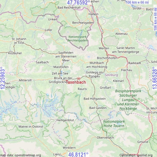
Taxenbach GPS coordinates[2]
47° 17' 28.176" North, 12° 57' 43.74" East
| Map corner | latitude | longitude |
|---|---|---|
| Upper-left | 47.76592°, | 12.25903° |
| Center: | 47.29116°, | 12.96215° |
| Lower-right: | 46.8121°, | 13.66528° |
| Map W x H: | 106.1×106.1 km | = 65.9×65.9mi |
| max Lat: | 48.98333° ⇑66% North |
| Taxenbach: | 47.29116° |
| min Lat: | ⇓34% South 46.48841° |
| min Long | Taxenbach | max Long |
| 9.57802° | 12.96215° | 17.1° |
| W 16.5%⇐ | ⇒83.5% E |
Elevation
Elevation of Taxenbach is 741 m = 2431 ft, and this is 235.5 m = 773 ft above average elevation for this country.
| Max E: |
2140 m = 7021 ft | 18.7% |
| Taxenbach | 741 m 2431 ft | |
| Avg. | 505.5 m = 1658 ft | |
Min E: |
118 m = 387 ft | 81.3% |
See also: Austria elevation on elevation.city.
Geographical zone
Taxenbach is located in North temperate zone (between Tropic of Cancer and the Arctic Circle). Distance of this North polar circle is 2142.9 km =1331.5 mi to North.| Distance of | km | miles | from Taxenbach |
|---|---|---|---|
| North Pole | 4748.8 | 2950.8 | to North |
| Arctic Circle | 2142.9 | 1331.5 | to North |
| Tropic Cancer | 2652.4 | 1648.1 | to South |
| Equator | 5258.3 | 3267.4 | to South |


Nearby cities:
15 places around Taxenbach: (largest is in red/bold)
• Atzing
14.3 km =8.9 mi,  301°
301°
• Bruck an der Großglocknerstraße
10.5 km =6.5 mi,  266°
266°
• Dienten am Hochkönig
10.7 km =6.6 mi,  16°
16°
• Dorfgastein
11.9 km =7.4 mi,  117°
117°
• Goldegg
10.8 km =6.7 mi,  73°
73°
• Krössenbach
11 km =6.8 mi, 265°
• Lend
6.8 km =4.2 mi,  83°
83°
• Maria Alm am Steinernen Meer
13.5 km =8.4 mi,  340°
340°
• Pichl
8.5 km =5.3 mi,  264°
264°
• Rauris
7.6 km =4.7 mi,  161°
161°
• Schmitten
14.5 km =9 mi,  285°
285°
• Schwarzach im Pongau
14.7 km =9.1 mi, 77°
• Thumersbach
11.8 km =7.3 mi, 291°
• Wörtherberg
9.1 km =5.7 mi,  169°
169°
• Zell am See
13.2 km =8.2 mi, 286°
Sources, notices
• [Note1] Compared only with cities in Austria existing in our database
• [Src1] Map data: © OpenStreetMap contributors (CC-BY-SA)
• [Src2] Other city data from geonames.org with taken over terms of usage.
• [Src3] Geographical zone / Annual Mean Temperature by Robert A. Rohde @ Wikipedia
