Rauris geodata
Rauris (Salzburg) is a seat of a third-order administrative division; located in Austria in Europe/Vienna (GMT+2) time zone. With population of 1,146 people, there are 1103 cities with bigger population in this country. Compared to other cities in Austria, 70.6% of cities are located further ↑North; 83.1% of cities are located further →East and 92.6% of cities have lower elevation than Rauris. Note1
Administrative division(s):
- Level 1: Salzburg
- Level 2: Politischer Bezirk Zell am See
- Level 3: Rauris


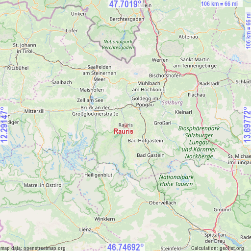
Rauris GPS coordinates[2]
47° 13' 35.616" North, 12° 59' 40.524" East
| Map corner | latitude | longitude |
|---|---|---|
| Upper-left | 47.7019°, | 12.29147° |
| Center: | 47.22656°, | 12.99459° |
| Lower-right: | 46.74692°, | 13.69772° |
| Map W x H: | 106.2×106.2 km | = 66×66mi |
| max Lat: | 48.98333° ⇑70.6% North |
| Rauris: | 47.22656° |
| min Lat: | ⇓29.4% South 46.48841° |
| min Long | Rauris | max Long |
| 9.57802° | 12.99459° | 17.1° |
| W 16.9%⇐ | ⇒83.1% E |
Elevation
Elevation of Rauris is 945 m = 3100 ft, and this is 439.5 m = 1442 ft above average elevation for this country.
| Max E: |
2140 m = 7021 ft | 7.4% |
| Rauris | 945 m 3100 ft | |
| Avg. | 505.5 m = 1658 ft | |
Min E: |
118 m = 387 ft | 92.6% |
See also: Austria elevation on elevation.city.
Geographical zone
Rauris is located in North temperate zone (between Tropic of Cancer and the Arctic Circle). Distance of this North polar circle is 2150.1 km =1336 mi to North.| Distance of | km | miles | from Rauris |
|---|---|---|---|
| North Pole | 4756 | 2955.2 | to North |
| Arctic Circle | 2150.1 | 1336 | to North |
| Tropic Cancer | 2645.2 | 1643.7 | to South |
| Equator | 5251.1 | 3262.9 | to South |


Nearby cities:
15 places around Rauris: (largest is in red/bold)
• Anger
11.5 km =7.1 mi,  133°
133°
• Bad Gastein
16.3 km =10.1 mi,  139°
139°
• Bad Hofgastein
9.9 km =6.2 mi, 127°
• Bruck an der Großglocknerstraße
14.5 km =9 mi,  296°
296°
• Dorfgastein
8.3 km =5.2 mi,  78°
78°
• Goldegg
12.9 km =8 mi,  37°
37°
• Grossarl
15.5 km =9.6 mi,  87°
87°
• Heissingfelding
11.2 km =7 mi, 127°
• Krössenbach
14.8 km =9.2 mi, 295°
• Lend
9.1 km =5.7 mi,  28°
28°
• Pichl
12.6 km =7.8 mi, 300°
• Schwarzach im Pongau
15.8 km =9.8 mi,  48°
48°
• Taxenbach
7.6 km =4.7 mi,  341°
341°
• Vorderschneeberg
12.6 km =7.8 mi, 136°
• Wörtherberg
2 km =1.2 mi,  203°
203°
Sources, notices
• [Note1] Compared only with cities in Austria existing in our database
• [Src1] Map data: © OpenStreetMap contributors (CC-BY-SA)
• [Src2] Other city data from geonames.org with taken over terms of usage.
• [Src3] Geographical zone / Annual Mean Temperature by Robert A. Rohde @ Wikipedia
