Lend geodata
Lend (Salzburg) is a seat of a third-order administrative division; located in Austria in Europe/Vienna (GMT+2) time zone. With population of 603 people, there are 2129 cities with bigger population in this country. Compared to other cities in Austria, 65.6% of cities are located further ↑North; 82.3% of cities are located further →East and 74.3% of cities have lower elevation than Lend. Note1


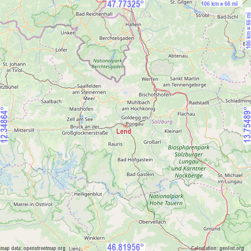
Lend GPS coordinates[2]
47° 17' 54.816" North, 13° 3' 6.336" East
| Map corner | latitude | longitude |
|---|---|---|
| Upper-left | 47.77325°, | 12.34864° |
| Center: | 47.29856°, | 13.05176° |
| Lower-right: | 46.81956°, | 13.75489° |
| Map W x H: | 106×106 km | = 65.9×65.9mi |
| max Lat: | 48.98333° ⇑65.6% North |
| Lend: | 47.29856° |
| min Lat: | ⇓34.4% South 46.48841° |
| min Long | Lend | max Long |
| 9.57802° | 13.05176° | 17.1° |
| W 17.7%⇐ | ⇒82.3% E |
Elevation
Elevation of Lend is 640 m = 2100 ft, and this is 134.5 m = 441 ft above average elevation for this country.
| Max E: |
2140 m = 7021 ft | 25.7% |
| Lend | 640 m 2100 ft | |
| Avg. | 505.5 m = 1658 ft | |
Min E: |
118 m = 387 ft | 74.3% |
See also: Austria elevation on elevation.city.
Geographical zone
Lend is located in North temperate zone (between Tropic of Cancer and the Arctic Circle). Distance of this North polar circle is 2142.1 km =1331 mi to North.| Distance of | km | miles | from Lend |
|---|---|---|---|
| North Pole | 4748 | 2950.3 | to North |
| Arctic Circle | 2142.1 | 1331 | to North |
| Tropic Cancer | 2653.2 | 1648.6 | to South |
| Equator | 5259.1 | 3267.9 | to South |


Nearby cities:
15 places around Lend: (largest is in red/bold)
• Dienten am Hochkönig
10.1 km =6.3 mi,  338°
338°
• Dorfgastein
7.4 km =4.6 mi,  148°
148°
• Goldegg
4.2 km =2.6 mi,  57°
57°
• Grossarl
13.3 km =8.3 mi,  122°
122°
• Maschl
13.5 km =8.4 mi, 55°
• Mühlbach am Hochkönig
10.5 km =6.5 mi,  33°
33°
• Plankenau
11.1 km =6.9 mi,  73°
73°
• Rauris
9.1 km =5.7 mi,  208°
208°
• Reinbach
11.8 km =7.3 mi, 62°
• Rettenstein
13.7 km =8.5 mi, 65°
• Sankt Johann im Pongau
12.6 km =7.8 mi, 62°
• Sankt Veit im Pongau
8.4 km =5.2 mi, 62°
• Schwarzach im Pongau
7.9 km =4.9 mi, 72°
• Taxenbach
6.8 km =4.2 mi,  263°
263°
• Wörtherberg
11.1 km =6.9 mi, 207°
Sources, notices
• [Note1] Compared only with cities in Austria existing in our database
• [Src1] Map data: © OpenStreetMap contributors (CC-BY-SA)
• [Src2] Other city data from geonames.org with taken over terms of usage.
• [Src3] Geographical zone / Annual Mean Temperature by Robert A. Rohde @ Wikipedia
