Siegenfeld geodata
Siegenfeld (Lower Austria) is a populated place; located in Austria in Europe/Vienna (GMT+2) time zone. With population of 718 people, there are 1808 cities with bigger population in this country. Compared to other cities in Austria, 68.8% of cities are located further ↓South; 85.5% of cities are located further ←West and 64.5% of cities have higher elevation than Siegenfeld. Note1
Administrative division(s):
- Level 1: Lower Austria
- Level 2: Politischer Bezirk Baden
- Level 3: Heiligenkreuz


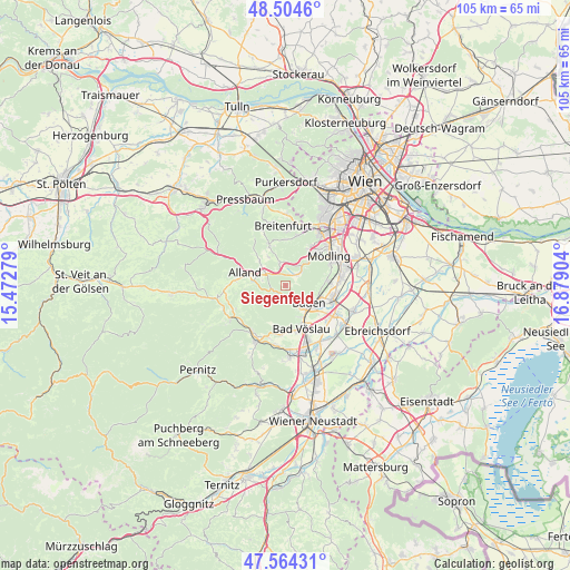
Siegenfeld GPS coordinates[2]
48° 2' 11.76" North, 16° 10' 33.276" East
| Map corner | latitude | longitude |
|---|---|---|
| Upper-left | 48.5046°, | 15.47279° |
| Center: | 48.0366°, | 16.17591° |
| Lower-right: | 47.56431°, | 16.87904° |
| Map W x H: | 104.6×104.5 km | = 65×64.9mi |
| max Lat: | 48.98333° ⇑31.2% North |
| Siegenfeld: | 48.0366° |
| min Lat: | ⇓68.8% South 46.48841° |
| min Long | Siegenfeld | max Long |
| 9.57802° | 16.17591° | 17.1° |
| W 85.5%⇐ | ⇒14.5% E |
Elevation
Elevation of Siegenfeld is 356 m = 1168 ft, and this is 149.5 m = 490 ft below average elevation for this country.
| Max E: |
2140 m = 7021 ft | 64.5% |
| Avg. | 505.5 m = 1658 ft | |
| Siegenfeld | 356 m = 1168 ft | |
Min E: |
118 m = 387 ft | 35.5% |
See also: Austria elevation on elevation.city.
Geographical zone
Siegenfeld is located in North temperate zone (between Tropic of Cancer and the Arctic Circle). Distance of this North polar circle is 2060 km =1280 mi to North.| Distance of | km | miles | from Siegenfeld |
|---|---|---|---|
| North Pole | 4665.9 | 2899.3 | to North |
| Arctic Circle | 2060 | 1280 | to North |
| Tropic Cancer | 2735.3 | 1699.6 | to South |
| Equator | 5341.2 | 3318.9 | to South |


Nearby cities:
15 places around Siegenfeld: (largest is in red/bold)
• Alland
7.6 km =4.7 mi,  288°
288°
• Bad Vöslau
8.4 km =5.2 mi,  160°
160°
• Baden
5.5 km =3.4 mi,  129°
129°
• Gaaden
2.6 km =1.6 mi,  43°
43°
• Gainfarn
8.3 km =5.2 mi,  170°
170°
• Gießhübl
8.1 km =5 mi,  32°
32°
• Grub
6.7 km =4.2 mi,  314°
314°
• Gumpoldskirchen
7.6 km =4.7 mi,  82°
82°
• Heiligenkreuz
4.3 km =2.7 mi,  299°
299°
• Hinterbrühl
7.7 km =4.8 mi, 44°
• Pfaffstätten
6.9 km =4.3 mi,  108°
108°
• Sittendorf
4.4 km =2.7 mi,  347°
347°
• Sooss
6.5 km =4 mi,  151°
151°
• Sulz im Wienerwald
7.6 km =4.7 mi,  338°
338°
• Tribuswinkel
7.8 km =4.8 mi,  115°
115°
Sources, notices
• [Note1] Compared only with cities in Austria existing in our database
• [Src1] Map data: © OpenStreetMap contributors (CC-BY-SA)
• [Src2] Other city data from geonames.org with taken over terms of usage.
• [Src3] Geographical zone / Annual Mean Temperature by Robert A. Rohde @ Wikipedia
