Alland geodata
Alland (Lower Austria) is a seat of a third-order administrative division; located in Austria in Europe/Vienna (GMT+2) time zone. With population of 1,470 people, there are 855 cities with bigger population in this country. Compared to other cities in Austria, 70.1% of cities are located further ↓South; 82.3% of cities are located further ←West and 70.5% of cities have higher elevation than Alland. Note1
Administrative division(s):
- Level 1: Lower Austria
- Level 2: Politischer Bezirk Baden
- Level 3: Alland


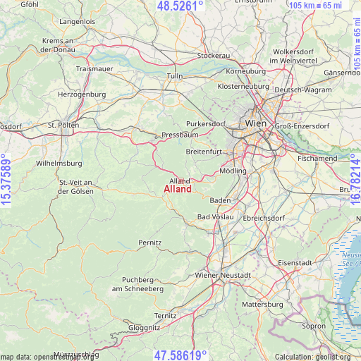
Alland GPS coordinates[2]
48° 3' 29.844" North, 16° 4' 44.436" East
| Map corner | latitude | longitude |
|---|---|---|
| Upper-left | 48.5261°, | 15.37589° |
| Center: | 48.05829°, | 16.07901° |
| Lower-right: | 47.58619°, | 16.78214° |
| Map W x H: | 104.5×104.5 km | = 64.9×64.9mi |
| max Lat: | 48.98333° ⇑29.9% North |
| Alland: | 48.05829° |
| min Lat: | ⇓70.1% South 46.48841° |
| min Long | Alland | max Long |
| 9.57802° | 16.07901° | 17.1° |
| W 82.3%⇐ | ⇒17.7% E |
Elevation
Elevation of Alland is 325 m = 1066 ft, and this is 180.5 m = 592 ft below average elevation for this country.
| Max E: |
2140 m = 7021 ft | 70.5% |
| Avg. | 505.5 m = 1658 ft | |
| Alland | 325 m = 1066 ft | |
Min E: |
118 m = 387 ft | 29.5% |
See also: Austria elevation on elevation.city.
Geographical zone
Alland is located in North temperate zone (between Tropic of Cancer and the Arctic Circle). Distance of this North polar circle is 2057.6 km =1278.5 mi to North.| Distance of | km | miles | from Alland |
|---|---|---|---|
| North Pole | 4663.5 | 2897.8 | to North |
| Arctic Circle | 2057.6 | 1278.5 | to North |
| Tropic Cancer | 2737.7 | 1701.1 | to South |
| Equator | 5343.6 | 3320.4 | to South |


Nearby cities:
15 places around Alland: (largest is in red/bold)
• Altenmarkt an der Triesting
7.8 km =4.8 mi,  232°
232°
• Breitenfurt bei Wien
9.9 km =6.2 mi,  32°
32°
• Gaaden
9 km =5.6 mi,  93°
93°
• Grub
3.4 km =2.1 mi,  46°
46°
• Heiligenkreuz
3.4 km =2.1 mi,  95°
95°
• Kaltenleutgeben
11 km =6.8 mi, 54°
• Klausen-Leopoldsdorf
5.7 km =3.5 mi,  305°
305°
• Neuhaus
7.4 km =4.6 mi,  199°
199°
• Pfalzau
11.4 km =7.1 mi,  353°
353°
• Pottenstein
11.2 km =7 mi,  173°
173°
• Siegenfeld
7.6 km =4.7 mi,  108°
108°
• Sittendorf
6.5 km =4 mi,  72°
72°
• Sulz im Wienerwald
6.4 km =4 mi,  42°
42°
• Thenneberg
9.6 km =6 mi,  241°
241°
• Weissenbach an der Triesting
9 km =5.6 mi, 199°
Sources, notices
• [Note1] Compared only with cities in Austria existing in our database
• [Src1] Map data: © OpenStreetMap contributors (CC-BY-SA)
• [Src2] Other city data from geonames.org with taken over terms of usage.
• [Src3] Geographical zone / Annual Mean Temperature by Robert A. Rohde @ Wikipedia
