Gaaden geodata
Gaaden (Lower Austria) is a seat of a third-order administrative division; located in Austria in Europe/Vienna (GMT+2) time zone. With population of 1,624 people, there are 766 cities with bigger population in this country. Compared to other cities in Austria, 69.8% of cities are located further ↓South; 86% of cities are located further ←West and 72.1% of cities have higher elevation than Gaaden. Note1
Administrative division(s):
- Level 1: Lower Austria
- Level 2: Politischer Bezirk Mödling
- Level 3: Gaaden


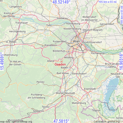
Gaaden GPS coordinates[2]
48° 3' 13.104" North, 16° 12' 0.108" East
| Map corner | latitude | longitude |
|---|---|---|
| Upper-left | 48.52149°, | 15.49691° |
| Center: | 48.05364°, | 16.20003° |
| Lower-right: | 47.5815°, | 16.90316° |
| Map W x H: | 104.5×104.5 km | = 64.9×64.9mi |
| max Lat: | 48.98333° ⇑30.2% North |
| Gaaden: | 48.05364° |
| min Lat: | ⇓69.8% South 46.48841° |
| min Long | Gaaden | max Long |
| 9.57802° | 16.20003° | 17.1° |
| W 86%⇐ | ⇒14% E |
Elevation
Elevation of Gaaden is 318 m = 1043 ft, and this is 187.5 m = 615 ft below average elevation for this country.
| Max E: |
2140 m = 7021 ft | 72.1% |
| Avg. | 505.5 m = 1658 ft | |
| Gaaden | 318 m = 1043 ft | |
Min E: |
118 m = 387 ft | 27.9% |
See also: Austria elevation on elevation.city.
Geographical zone
Gaaden is located in North temperate zone (between Tropic of Cancer and the Arctic Circle). Distance of this North polar circle is 2058.1 km =1278.8 mi to North.| Distance of | km | miles | from Gaaden |
|---|---|---|---|
| North Pole | 4664 | 2898.1 | to North |
| Arctic Circle | 2058.1 | 1278.8 | to North |
| Tropic Cancer | 2737.1 | 1700.8 | to South |
| Equator | 5343.1 | 3320 | to South |


Nearby cities:
15 places around Gaaden: (largest is in red/bold)
• Baden
5.9 km =3.7 mi,  155°
155°
• Gießhübl
5.5 km =3.4 mi,  27°
27°
• Grub
7.2 km =4.5 mi,  293°
293°
• Gumpoldskirchen
5.8 km =3.6 mi,  99°
99°
• Heiligenkreuz
5.6 km =3.5 mi,  272°
272°
• Hinterbrühl
5.1 km =3.2 mi,  44°
44°
• Kaltenleutgeben
7 km =4.3 mi,  359°
359°
• Maria Enzersdorf
8.1 km =5 mi,  50°
50°
• Mödling
7.5 km =4.7 mi,  61°
61°
• Pfaffstätten
6.2 km =3.9 mi,  130°
130°
• Siegenfeld
2.6 km =1.6 mi,  223°
223°
• Sittendorf
3.7 km =2.3 mi,  311°
311°
• Sooss
7.8 km =4.8 mi,  170°
170°
• Sulz im Wienerwald
7 km =4.3 mi,  318°
318°
• Tribuswinkel
7.4 km =4.6 mi,  135°
135°
Sources, notices
• [Note1] Compared only with cities in Austria existing in our database
• [Src1] Map data: © OpenStreetMap contributors (CC-BY-SA)
• [Src2] Other city data from geonames.org with taken over terms of usage.
• [Src3] Geographical zone / Annual Mean Temperature by Robert A. Rohde @ Wikipedia
