Semriach geodata
Semriach (Styria) is a seat of a third-order administrative division; located in Austria in Europe/Vienna (GMT+2) time zone. With population of 1,392 people, there are 903 cities with bigger population in this country. Compared to other cities in Austria, 71.6% of cities are located further ↑North; 62.5% of cities are located further ←West and 78.6% of cities have lower elevation than Semriach. Note1
Administrative division(s):
- Level 1: Styria
- Level 2: Politischer Bezirk Graz-Umgebung
- Level 3: Semriach


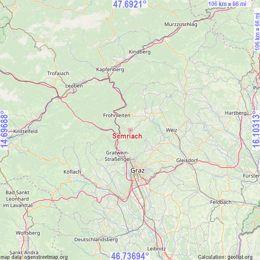
Semriach GPS coordinates[2]
47° 13' 0.012" North, 15° 24' 0" East
| Map corner | latitude | longitude |
|---|---|---|
| Upper-left | 47.6921°, | 14.69688° |
| Center: | 47.21667°, | 15.4° |
| Lower-right: | 46.73694°, | 16.10313° |
| Map W x H: | 106.2×106.2 km | = 66×66mi |
| max Lat: | 48.98333° ⇑71.6% North |
| Semriach: | 47.21667° |
| min Lat: | ⇓28.4% South 46.48841° |
| min Long | Semriach | max Long |
| 9.57802° | 15.4° | 17.1° |
| W 62.5%⇐ | ⇒37.5% E |
Elevation
Elevation of Semriach is 695 m = 2280 ft, and this is 189.5 m = 622 ft above average elevation for this country.
| Max E: |
2140 m = 7021 ft | 21.4% |
| Semriach | 695 m 2280 ft | |
| Avg. | 505.5 m = 1658 ft | |
Min E: |
118 m = 387 ft | 78.6% |
See also: Austria elevation on elevation.city.
Geographical zone
Semriach is located in North temperate zone (between Tropic of Cancer and the Arctic Circle). Distance of this North polar circle is 2151.2 km =1336.7 mi to North.| Distance of | km | miles | from Semriach |
|---|---|---|---|
| North Pole | 4757.1 | 2955.9 | to North |
| Arctic Circle | 2151.2 | 1336.7 | to North |
| Tropic Cancer | 2644.1 | 1643 | to South |
| Equator | 5250 | 3262.2 | to South |


Nearby cities:
15 places around Semriach: (largest is in red/bold)
• Arzberg
9.6 km =6 mi,  67°
67°
• Deutschfeistritz
5.2 km =3.2 mi,  247°
247°
• Fladnitz an der Teichalm
9.6 km =6 mi,  37°
37°
• Forstviertel
8.3 km =5.2 mi,  207°
207°
• Freßnitzviertel
5.7 km =3.5 mi,  192°
192°
• Frohnleiten
8.4 km =5.2 mi,  311°
311°
• Hub
7.5 km =4.7 mi,  170°
170°
• Kleinstübing
7.3 km =4.5 mi,  239°
239°
• Peggau
4.2 km =2.6 mi, 243°
• Rinnegg
9 km =5.6 mi,  132°
132°
• Sankt Radegund bei Graz
8 km =5 mi,  119°
119°
• Schrems bei Frohnleiten
7.8 km =4.8 mi,  336°
336°
• Stattegg
9.4 km =5.8 mi, 172°
• Stenzengreith
9 km =5.6 mi,  101°
101°
• Ursprung
9.6 km =6 mi,  164°
164°
Sources, notices
• [Note1] Compared only with cities in Austria existing in our database
• [Src1] Map data: © OpenStreetMap contributors (CC-BY-SA)
• [Src2] Other city data from geonames.org with taken over terms of usage.
• [Src3] Geographical zone / Annual Mean Temperature by Robert A. Rohde @ Wikipedia
