Kleinstübing geodata
Kleinstübing (Styria) is a populated place; located in Austria in Europe/Vienna (GMT+2) time zone. With population of 761 people, there are 1698 cities with bigger population in this country. Compared to other cities in Austria, 74.1% of cities are located further ↑North; 60.5% of cities are located further ←West and 62.6% of cities have lower elevation than Kleinstübing. Note1
Administrative division(s):
- Level 1: Styria
- Level 2: Politischer Bezirk Graz-Umgebung
- Level 3: Deutschfeistritz


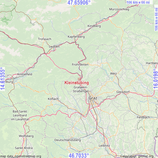
Kleinstübing GPS coordinates[2]
47° 10' 59.988" North, 15° 19' 0.012" East
| Map corner | latitude | longitude |
|---|---|---|
| Upper-left | 47.65906°, | 14.61355° |
| Center: | 47.18333°, | 15.31667° |
| Lower-right: | 46.7033°, | 16.0198° |
| Map W x H: | 106.3×106.3 km | = 66.1×66.1mi |
| max Lat: | 48.98333° ⇑74.1% North |
| Kleinstübing: | 47.18333° |
| min Lat: | ⇓25.9% South 46.48841° |
| min Long | Kleinstübing | max Long |
| 9.57802° | 15.31667° | 17.1° |
| W 60.5%⇐ | ⇒39.5% E |
Elevation
Elevation of Kleinstübing is 536 m = 1759 ft, and this is 30.5 m = 100 ft above average elevation for this country.
| Max E: |
2140 m = 7021 ft | 37.4% |
| Kleinstübing | 536 m 1759 ft | |
| Avg. | 505.5 m = 1658 ft | |
Min E: |
118 m = 387 ft | 62.6% |
See also: Austria elevation on elevation.city.
Geographical zone
Kleinstübing is located in North temperate zone (between Tropic of Cancer and the Arctic Circle). Distance of this North polar circle is 2154.9 km =1339 mi to North.| Distance of | km | miles | from Kleinstübing |
|---|---|---|---|
| North Pole | 4760.8 | 2958.2 | to North |
| Arctic Circle | 2154.9 | 1339 | to North |
| Tropic Cancer | 2640.4 | 1640.7 | to South |
| Equator | 5246.3 | 3259.9 | to South |


Nearby cities:
15 places around Kleinstübing: (largest is in red/bold)
• Deutschfeistritz
2.2 km =1.4 mi,  41°
41°
• Forstviertel
4.5 km =2.8 mi,  145°
145°
• Freßnitzviertel
5.4 km =3.4 mi,  110°
110°
• Gratkorn
6.1 km =3.8 mi,  155°
155°
• Gratwein
7.4 km =4.6 mi,  180°
180°
• Hörgas
3.9 km =2.4 mi,  198°
198°
• Judendorf
7.8 km =4.8 mi, 161°
• Kirchenviertel
6.2 km =3.9 mi, 157°
• Land-Übelbach
6.1 km =3.8 mi,  313°
313°
• Peggau
3.1 km =1.9 mi,  53°
53°
• Rein
6.1 km =3.8 mi, 204°
• Rötz
7.4 km =4.6 mi, 180°
• Semriach
7.3 km =4.5 mi,  59°
59°
• Strassengel
7.6 km =4.7 mi,  170°
170°
• Übelbach
7.7 km =4.8 mi, 307°
Sources, notices
• [Note1] Compared only with cities in Austria existing in our database
• [Src1] Map data: © OpenStreetMap contributors (CC-BY-SA)
• [Src2] Other city data from geonames.org with taken over terms of usage.
• [Src3] Geographical zone / Annual Mean Temperature by Robert A. Rohde @ Wikipedia
