Rettenstein geodata
Rettenstein (Salzburg) is a populated place; located in Austria in Europe/Vienna (GMT+2) time zone. With population of 689 people, there are 1886 cities with bigger population in this country. Compared to other cities in Austria, 62.8% of cities are located further ↑North; 78.8% of cities are located further →East and 82.5% of cities have lower elevation than Rettenstein. Note1
Administrative division(s):
- Level 1: Salzburg
- Level 2: Politischer Bezirk Sankt Johann im Pongau
- Level 3: St. Johann im Pongau


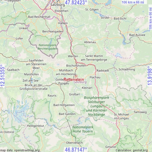
Rettenstein GPS coordinates[2]
47° 21' 0" North, 13° 13' 0.012" East
| Map corner | latitude | longitude |
|---|---|---|
| Upper-left | 47.82423°, | 12.51355° |
| Center: | 47.35°, | 13.21667° |
| Lower-right: | 46.87147°, | 13.9198° |
| Map W x H: | 105.9×105.9 km | = 65.8×65.8mi |
| max Lat: | 48.98333° ⇑62.8% North |
| Rettenstein: | 47.35° |
| min Lat: | ⇓37.2% South 46.48841° |
| min Long | Rettenstein | max Long |
| 9.57802° | 13.21667° | 17.1° |
| W 21.2%⇐ | ⇒78.8% E |
Elevation
Elevation of Rettenstein is 758 m = 2487 ft, and this is 252.5 m = 828 ft above average elevation for this country.
| Max E: |
2140 m = 7021 ft | 17.5% |
| Rettenstein | 758 m 2487 ft | |
| Avg. | 505.5 m = 1658 ft | |
Min E: |
118 m = 387 ft | 82.5% |
See also: Austria elevation on elevation.city.
Geographical zone
Rettenstein is located in North temperate zone (between Tropic of Cancer and the Arctic Circle). Distance of this North polar circle is 2136.3 km =1327.4 mi to North.| Distance of | km | miles | from Rettenstein |
|---|---|---|---|
| North Pole | 4742.2 | 2946.7 | to North |
| Arctic Circle | 2136.3 | 1327.4 | to North |
| Tropic Cancer | 2658.9 | 1652.2 | to South |
| Equator | 5264.8 | 3271.4 | to South |


Nearby cities:
15 places around Rettenstein: (largest is in red/bold)
• Bischofshofen
7.4 km =4.6 mi,  0°
0°
• Goldegg
9.5 km =5.9 mi,  248°
248°
• Hof
7.5 km =4.7 mi,  90°
90°
• Hofmarkt
7.8 km =4.8 mi,  123°
123°
• Hüttau
10.1 km =6.3 mi,  43°
43°
• Laideregg
7.5 km =4.7 mi,  350°
350°
• Maschl
2.2 km =1.4 mi,  325°
325°
• Mitterberghütten
5.6 km =3.5 mi, 0°
• Mühlbach am Hochkönig
7.3 km =4.5 mi,  294°
294°
• Plankenau
3.2 km =2 mi,  214°
214°
• Reinbach
2 km =1.2 mi,  259°
259°
• Sankt Johann im Pongau
1.3 km =0.8 mi,  270°
270°
• Sankt Veit im Pongau
5.4 km =3.4 mi, 249°
• Schwarzach im Pongau
5.9 km =3.7 mi,  236°
236°
• Wagrain
6.4 km =4 mi,  104°
104°
Sources, notices
• [Note1] Compared only with cities in Austria existing in our database
• [Src1] Map data: © OpenStreetMap contributors (CC-BY-SA)
• [Src2] Other city data from geonames.org with taken over terms of usage.
• [Src3] Geographical zone / Annual Mean Temperature by Robert A. Rohde @ Wikipedia
