Hüttau geodata
Hüttau (Salzburg) is a seat of a third-order administrative division; located in Austria in Europe/Vienna (GMT+2) time zone. With population of 410 people, there are 2605 cities with bigger population in this country. Compared to other cities in Austria, 58.7% of cities are located further ↑North; 77.7% of cities are located further →East and 78.8% of cities have lower elevation than Hüttau. Note1
Administrative division(s):
- Level 1: Salzburg
- Level 2: Politischer Bezirk Sankt Johann im Pongau
- Level 3: Hüttau


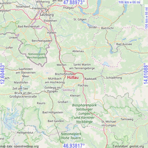
Hüttau GPS coordinates[2]
47° 24' 57.96" North, 13° 18' 27.9" East
| Map corner | latitude | longitude |
|---|---|---|
| Upper-left | 47.88973°, | 12.60463° |
| Center: | 47.4161°, | 13.30775° |
| Lower-right: | 46.93817°, | 14.01088° |
| Map W x H: | 105.8×105.8 km | = 65.7×65.7mi |
| max Lat: | 48.98333° ⇑58.7% North |
| Hüttau: | 47.4161° |
| min Lat: | ⇓41.3% South 46.48841° |
| min Long | Hüttau | max Long |
| 9.57802° | 13.30775° | 17.1° |
| W 22.3%⇐ | ⇒77.7% E |
Elevation
Elevation of Hüttau is 697 m = 2287 ft, and this is 191.5 m = 628 ft above average elevation for this country.
| Max E: |
2140 m = 7021 ft | 21.2% |
| Hüttau | 697 m 2287 ft | |
| Avg. | 505.5 m = 1658 ft | |
Min E: |
118 m = 387 ft | 78.8% |
See also: Austria elevation on elevation.city.
Geographical zone
Hüttau is located in North temperate zone (between Tropic of Cancer and the Arctic Circle). Distance of this North polar circle is 2129 km =1322.9 mi to North.| Distance of | km | miles | from Hüttau |
|---|---|---|---|
| North Pole | 4734.9 | 2942.1 | to North |
| Arctic Circle | 2129 | 1322.9 | to North |
| Tropic Cancer | 2666.3 | 1656.8 | to South |
| Equator | 5272.2 | 3276 | to South |


Nearby cities:
15 places around Hüttau: (largest is in red/bold)
• Altenmarkt im Pongau
9 km =5.6 mi,  113°
113°
• Am Feuersang
8.9 km =5.5 mi,  128°
128°
• Bischofshofen
6.9 km =4.3 mi,  270°
270°
• Dorfwerfen
9 km =5.6 mi,  301°
301°
• Eben im Pongau
7.2 km =4.5 mi,  104°
104°
• Hof
7.4 km =4.6 mi,  174°
174°
• Höch
7.9 km =4.9 mi, 134°
• Laideregg
8.1 km =5 mi, 270°
• Mitterberghütten
7.1 km =4.4 mi,  255°
255°
• Pfarrwerfen
9 km =5.6 mi, 300°
• Reitdorf
7.9 km =4.9 mi, 134°
• Sonnberg
0.7 km =0.4 mi,  84°
84°
• St. Martin of Tennengebirge
7.6 km =4.7 mi,  44°
44°
• Wagrain
9 km =5.6 mi,  184°
184°
• Werfenweng
6.4 km =4 mi,  322°
322°
Sources, notices
• [Note1] Compared only with cities in Austria existing in our database
• [Src1] Map data: © OpenStreetMap contributors (CC-BY-SA)
• [Src2] Other city data from geonames.org with taken over terms of usage.
• [Src3] Geographical zone / Annual Mean Temperature by Robert A. Rohde @ Wikipedia
