Rettenegg geodata
Rettenegg (Styria) is a seat of a third-order administrative division; located in Austria in Europe/Vienna (GMT+2) time zone. With population of 575 people, there are 2228 cities with bigger population in this country. Compared to other cities in Austria, 52.6% of cities are located further ↑North; 74.1% of cities are located further ←West and 88.9% of cities have lower elevation than Rettenegg. Note1


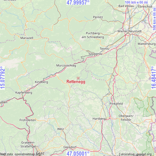
Rettenegg GPS coordinates[2]
47° 31' 36.984" North, 15° 46' 51.744" East
| Map corner | latitude | longitude |
|---|---|---|
| Upper-left | 47.99957°, | 15.07792° |
| Center: | 47.52694°, | 15.78104° |
| Lower-right: | 47.05001°, | 16.48417° |
| Map W x H: | 105.6×105.6 km | = 65.6×65.6mi |
| max Lat: | 48.98333° ⇑52.6% North |
| Rettenegg: | 47.52694° |
| min Lat: | ⇓47.4% South 46.48841° |
| min Long | Rettenegg | max Long |
| 9.57802° | 15.78104° | 17.1° |
| W 74.1%⇐ | ⇒25.9% E |
Elevation
Elevation of Rettenegg is 857 m = 2812 ft, and this is 351.5 m = 1153 ft above average elevation for this country.
| Max E: |
2140 m = 7021 ft | 11.1% |
| Rettenegg | 857 m 2812 ft | |
| Avg. | 505.5 m = 1658 ft | |
Min E: |
118 m = 387 ft | 88.9% |
See also: Austria elevation on elevation.city.
Geographical zone
Rettenegg is located in North temperate zone (between Tropic of Cancer and the Arctic Circle). Distance of this North polar circle is 2116.7 km =1315.3 mi to North.| Distance of | km | miles | from Rettenegg |
|---|---|---|---|
| North Pole | 4722.6 | 2934.5 | to North |
| Arctic Circle | 2116.7 | 1315.3 | to North |
| Tropic Cancer | 2678.6 | 1664.4 | to South |
| Equator | 5284.5 | 3283.6 | to South |


Nearby cities:
15 places around Rettenegg: (largest is in red/bold)
• Falkenstein
11.3 km =7 mi,  220°
220°
• Ganz
10.9 km =6.8 mi,  317°
317°
• Hönigsberg
11.6 km =7.2 mi,  300°
300°
• Karnerviertel
10.7 km =6.6 mi,  127°
127°
• Kirchenviertel
6.5 km =4 mi,  174°
174°
• Kirchenviertel
6.5 km =4 mi, 224°
• Klaffenegg
1.9 km =1.2 mi,  238°
238°
• Mönichwald
11.8 km =7.3 mi,  139°
139°
• Ratten
6.8 km =4.2 mi, 224°
• Sankt Jakob im Walde
6.7 km =4.2 mi,  178°
178°
• Sankt Kathrein am Hauenstein
7.7 km =4.8 mi, 237°
• Spital am Semmering
9.9 km =6.2 mi,  346°
346°
• Steinhaus am Semmering
10.1 km =6.3 mi,  8°
8°
• Sticklberg
0.4 km =0.2 mi,  339°
339°
• Trattenbach
10.4 km =6.5 mi,  38°
38°
Sources, notices
• [Note1] Compared only with cities in Austria existing in our database
• [Src1] Map data: © OpenStreetMap contributors (CC-BY-SA)
• [Src2] Other city data from geonames.org with taken over terms of usage.
• [Src3] Geographical zone / Annual Mean Temperature by Robert A. Rohde @ Wikipedia
