Rapperswinkel geodata
Rapperswinkel (Upper Austria) is a populated place; located in Austria in Europe/Vienna (GMT+2) time zone. With population of 805 people, there are 1607 cities with bigger population in this country. Compared to other cities in Austria, 80.3% of cities are located further ↓South; 59% of cities are located further →East and 81.7% of cities have higher elevation than Rapperswinkel. Note1
Administrative division(s):
- Level 1: Upper Austria
- Level 2: Politischer Bezirk Linz-Land
- Level 3: Ansfelden


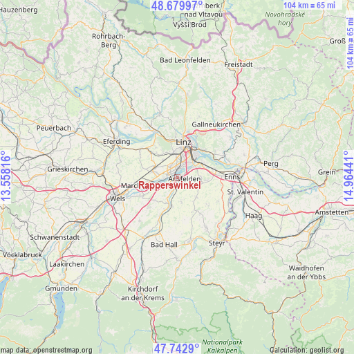
Rapperswinkel GPS coordinates[2]
48° 12' 48.888" North, 14° 15' 40.608" East
| Map corner | latitude | longitude |
|---|---|---|
| Upper-left | 48.67997°, | 13.55816° |
| Center: | 48.21358°, | 14.26128° |
| Lower-right: | 47.7429°, | 14.96441° |
| Map W x H: | 104.2×104.2 km | = 64.7×64.7mi |
| max Lat: | 48.98333° ⇑19.7% North |
| Rapperswinkel: | 48.21358° |
| min Lat: | ⇓80.3% South 46.48841° |
| min Long | Rapperswinkel | max Long |
| 9.57802° | 14.26128° | 17.1° |
| W 41%⇐ | ⇒59% E |
Elevation
Elevation of Rapperswinkel is 267 m = 876 ft, and this is 238.5 m = 782 ft below average elevation for this country.
| Max E: |
2140 m = 7021 ft | 81.7% |
| Avg. | 505.5 m = 1658 ft | |
| Rapperswinkel | 267 m = 876 ft | |
Min E: |
118 m = 387 ft | 18.3% |
See also: Austria elevation on elevation.city.
Geographical zone
Rapperswinkel is located in North temperate zone (between Tropic of Cancer and the Arctic Circle). Distance of this North polar circle is 2040.3 km =1267.8 mi to North.| Distance of | km | miles | from Rapperswinkel |
|---|---|---|---|
| North Pole | 4646.2 | 2887 | to North |
| Arctic Circle | 2040.3 | 1267.8 | to North |
| Tropic Cancer | 2754.9 | 1711.8 | to South |
| Equator | 5360.8 | 3331 | to South |


Nearby cities:
15 places around Rapperswinkel: (largest is in red/bold)
• Ansfelden
2.2 km =1.4 mi,  101°
101°
• Audorf
1.4 km =0.9 mi,  69°
69°
• Doppl
3.9 km =2.4 mi,  352°
352°
• Freindorf
2.8 km =1.7 mi,  61°
61°
• Haid
1.2 km =0.7 mi,  217°
217°
• Kremsdorf
1.5 km =0.9 mi,  176°
176°
• Langholzfeld
3.4 km =2.1 mi,  342°
342°
• Neubau
5.1 km =3.2 mi,  276°
276°
• Nöstlbach
5.3 km =3.3 mi,  192°
192°
• Oedt
3.8 km =2.4 mi,  269°
269°
• Sankt Dionysen
1.3 km =0.8 mi, 338°
• Sankt Martin
2 km =1.2 mi,  14°
14°
• Traun
2.4 km =1.5 mi,  306°
306°
• Wagram
3.6 km =2.2 mi,  319°
319°
• Öhndorf
5.3 km =3.3 mi,  263°
263°
Sources, notices
• [Note1] Compared only with cities in Austria existing in our database
• [Src1] Map data: © OpenStreetMap contributors (CC-BY-SA)
• [Src2] Other city data from geonames.org with taken over terms of usage.
• [Src3] Geographical zone / Annual Mean Temperature by Robert A. Rohde @ Wikipedia
