Langholzfeld geodata
Langholzfeld (Upper Austria) is a section of populated place; located in Austria in Europe/Vienna (GMT+2) time zone. With population of 3,622 people, there are 298 cities with bigger population in this country. Compared to other cities in Austria, 82.2% of cities are located further ↓South; 59.4% of cities are located further →East and 80.5% of cities have higher elevation than Langholzfeld. Note1
Administrative division(s):
- Level 1: Upper Austria
- Level 2: Politischer Bezirk Linz-Land
- Level 3: Pasching


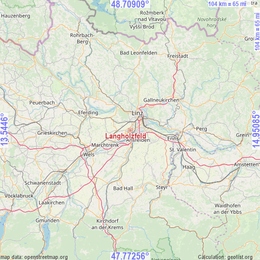
Langholzfeld GPS coordinates[2]
48° 14' 34.692" North, 14° 14' 51.792" East
| Map corner | latitude | longitude |
|---|---|---|
| Upper-left | 48.70909°, | 13.5446° |
| Center: | 48.24297°, | 14.24772° |
| Lower-right: | 47.77256°, | 14.95085° |
| Map W x H: | 104.1×104.1 km | = 64.7×64.7mi |
| max Lat: | 48.98333° ⇑17.8% North |
| Langholzfeld: | 48.24297° |
| min Lat: | ⇓82.2% South 46.48841° |
| min Long | Langholzfeld | max Long |
| 9.57802° | 14.24772° | 17.1° |
| W 40.6%⇐ | ⇒59.4% E |
Elevation
Elevation of Langholzfeld is 272 m = 892 ft, and this is 233.5 m = 766 ft below average elevation for this country.
| Max E: |
2140 m = 7021 ft | 80.5% |
| Avg. | 505.5 m = 1658 ft | |
| Langholzfeld | 272 m = 892 ft | |
Min E: |
118 m = 387 ft | 19.5% |
See also: Austria elevation on elevation.city.
Geographical zone
Langholzfeld is located in North temperate zone (between Tropic of Cancer and the Arctic Circle). Distance of this North polar circle is 2037.1 km =1265.8 mi to North.| Distance of | km | miles | from Langholzfeld |
|---|---|---|---|
| North Pole | 4642.9 | 2885 | to North |
| Arctic Circle | 2037.1 | 1265.8 | to North |
| Tropic Cancer | 2758.2 | 1713.9 | to South |
| Equator | 5364.1 | 3333.1 | to South |


Nearby cities:
15 places around Langholzfeld: (largest is in red/bold)
• Audorf
3.6 km =2.2 mi,  139°
139°
• Doppl
0.7 km =0.4 mi,  39°
39°
• Freindorf
4 km =2.5 mi,  118°
118°
• Haag
3.4 km =2.1 mi,  26°
26°
• Haid
4.3 km =2.7 mi,  176°
176°
• Hart
2.6 km =1.6 mi,  15°
15°
• Kinderdorf Sankt Isidor
2.7 km =1.7 mi, 29°
• Leonding
4.1 km =2.5 mi,  5°
5°
• Pasching
3.7 km =2.3 mi,  299°
299°
• Rapperswinkel
3.4 km =2.1 mi,  162°
162°
• Reith
2.6 km =1.6 mi,  353°
353°
• Sankt Dionysen
2.1 km =1.3 mi,  165°
165°
• Sankt Martin
2 km =1.2 mi,  132°
132°
• Traun
2.1 km =1.3 mi,  208°
208°
• Wagram
1.4 km =0.9 mi,  248°
248°
Sources, notices
• [Note1] Compared only with cities in Austria existing in our database
• [Src1] Map data: © OpenStreetMap contributors (CC-BY-SA)
• [Src2] Other city data from geonames.org with taken over terms of usage.
• [Src3] Geographical zone / Annual Mean Temperature by Robert A. Rohde @ Wikipedia
