Haid geodata
Haid (Upper Austria) is a populated place; located in Austria in Europe/Vienna (GMT+2) time zone. With population of 7,424 people, there are 123 cities with bigger population in this country. Compared to other cities in Austria, 79.6% of cities are located further ↓South; 59.4% of cities are located further →East and 79.5% of cities have higher elevation than Haid. Note1
Administrative division(s):
- Level 1: Upper Austria
- Level 2: Politischer Bezirk Linz-Land
- Level 3: Ansfelden


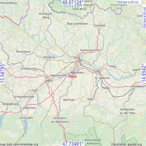
Haid GPS coordinates[2]
48° 12' 17.172" North, 14° 15' 3.852" East
| Map corner | latitude | longitude |
|---|---|---|
| Upper-left | 48.67124°, | 13.54795° |
| Center: | 48.20477°, | 14.25107° |
| Lower-right: | 47.73401°, | 14.9542° |
| Map W x H: | 104.2×104.2 km | = 64.7×64.7mi |
| max Lat: | 48.98333° ⇑20.4% North |
| Haid: | 48.20477° |
| min Lat: | ⇓79.6% South 46.48841° |
| min Long | Haid | max Long |
| 9.57802° | 14.25107° | 17.1° |
| W 40.6%⇐ | ⇒59.4% E |
Elevation
Elevation of Haid is 277 m = 909 ft, and this is 228.5 m = 750 ft below average elevation for this country.
| Max E: |
2140 m = 7021 ft | 79.5% |
| Avg. | 505.5 m = 1658 ft | |
| Haid | 277 m = 909 ft | |
Min E: |
118 m = 387 ft | 20.5% |
See also: Austria elevation on elevation.city.
Geographical zone
Haid is located in North temperate zone (between Tropic of Cancer and the Arctic Circle). Distance of this North polar circle is 2041.3 km =1268.4 mi to North.| Distance of | km | miles | from Haid |
|---|---|---|---|
| North Pole | 4647.2 | 2887.6 | to North |
| Arctic Circle | 2041.3 | 1268.4 | to North |
| Tropic Cancer | 2753.9 | 1711.2 | to South |
| Equator | 5359.9 | 3330.5 | to South |


Nearby cities:
15 places around Haid: (largest is in red/bold)
• Ansfelden
2.9 km =1.8 mi,  79°
79°
• Audorf
2.6 km =1.6 mi,  54°
54°
• Doppl
4.8 km =3 mi,  2°
2°
• Freindorf
4 km =2.5 mi, 54°
• Kremsdorf
1 km =0.6 mi,  120°
120°
• Langholzfeld
4.3 km =2.7 mi,  356°
356°
• Neubau
4.6 km =2.9 mi,  290°
290°
• Nöstlbach
4.3 km =2.7 mi,  184°
184°
• Oedt
3.2 km =2 mi, 287°
• Rapperswinkel
1.2 km =0.7 mi,  37°
37°
• Sankt Dionysen
2.2 km =1.4 mi,  7°
7°
• Sankt Martin
3.2 km =2 mi,  23°
23°
• Traun
2.7 km =1.7 mi,  333°
333°
• Wagram
4 km =2.5 mi,  337°
337°
• Öhndorf
4.5 km =2.8 mi,  275°
275°
Sources, notices
• [Note1] Compared only with cities in Austria existing in our database
• [Src1] Map data: © OpenStreetMap contributors (CC-BY-SA)
• [Src2] Other city data from geonames.org with taken over terms of usage.
• [Src3] Geographical zone / Annual Mean Temperature by Robert A. Rohde @ Wikipedia
