Ragnitz geodata
Ragnitz (Styria) is a seat of a third-order administrative division; located in Austria in Europe/Vienna (GMT+2) time zone. With population of 335 people, there are 2700 cities with bigger population in this country. Compared to other cities in Austria, 90% of cities are located further ↑North; 68.4% of cities are located further ←West and 79.2% of cities have higher elevation than Ragnitz. Note1


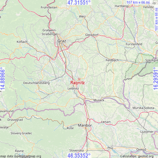
Ragnitz GPS coordinates[2]
46° 50' 12.012" North, 15° 35' 34.008" East
| Map corner | latitude | longitude |
|---|---|---|
| Upper-left | 47.31551°, | 14.88966° |
| Center: | 46.83667°, | 15.59278° |
| Lower-right: | 46.35352°, | 16.29591° |
| Map W x H: | 107×107 km | = 66.5×66.5mi |
| max Lat: | 48.98333° ⇑90% North |
| Ragnitz: | 46.83667° |
| min Lat: | ⇓10% South 46.48841° |
| min Long | Ragnitz | max Long |
| 9.57802° | 15.59278° | 17.1° |
| W 68.4%⇐ | ⇒31.6% E |
Elevation
Elevation of Ragnitz is 278 m = 912 ft, and this is 227.5 m = 746 ft below average elevation for this country.
| Max E: |
2140 m = 7021 ft | 79.2% |
| Avg. | 505.5 m = 1658 ft | |
| Ragnitz | 278 m = 912 ft | |
Min E: |
118 m = 387 ft | 20.8% |
See also: Austria elevation on elevation.city.
Geographical zone
Ragnitz is located in North temperate zone (between Tropic of Cancer and the Arctic Circle). Distance of this North polar circle is 2193.4 km =1362.9 mi to North.| Distance of | km | miles | from Ragnitz |
|---|---|---|---|
| North Pole | 4799.3 | 2982.1 | to North |
| Arctic Circle | 2193.4 | 1362.9 | to North |
| Tropic Cancer | 2601.8 | 1616.7 | to South |
| Equator | 5207.7 | 3235.9 | to South |


Nearby cities:
15 places around Ragnitz: (largest is in red/bold)
• Breitenfeld am Tannenriegel
3.4 km =2.1 mi,  64°
64°
• Gabersdorf
6.6 km =4.1 mi,  185°
185°
• Glojach
6.5 km =4 mi, 59°
• Gralla
3.8 km =2.4 mi,  228°
228°
• Hainsdorf im Schwarzautal
3.7 km =2.3 mi,  91°
91°
• Kaindorf an der Sulm
6.4 km =4 mi,  219°
219°
• Lebring
4.5 km =2.8 mi,  292°
292°
• Mitterlabill
6.7 km =4.2 mi,  29°
29°
• Neutillmitsch
5 km =3.1 mi,  243°
243°
• Sankt Georgen an der Stiefing
4.2 km =2.6 mi,  346°
346°
• Sankt Margarethen bei Lebring
5.8 km =3.6 mi,  301°
301°
• Sankt Nikolai ob Draßling
5.4 km =3.4 mi,  124°
124°
• Tillmitsch
6.4 km =4 mi, 244°
• Tillmitsch Links der Laßnitz
6 km =3.7 mi, 240°
• Wolfsberg im Schwarzautal
5.1 km =3.2 mi,  80°
80°
Sources, notices
• [Note1] Compared only with cities in Austria existing in our database
• [Src1] Map data: © OpenStreetMap contributors (CC-BY-SA)
• [Src2] Other city data from geonames.org with taken over terms of usage.
• [Src3] Geographical zone / Annual Mean Temperature by Robert A. Rohde @ Wikipedia
