Gralla geodata
Gralla (Styria) is a seat of a third-order administrative division; located in Austria in Europe/Vienna (GMT+2) time zone. With population of 2,390 people, there are 508 cities with bigger population in this country. Compared to other cities in Austria, 91.3% of cities are located further ↑North; 67% of cities are located further ←West and 79.2% of cities have higher elevation than Gralla. Note1


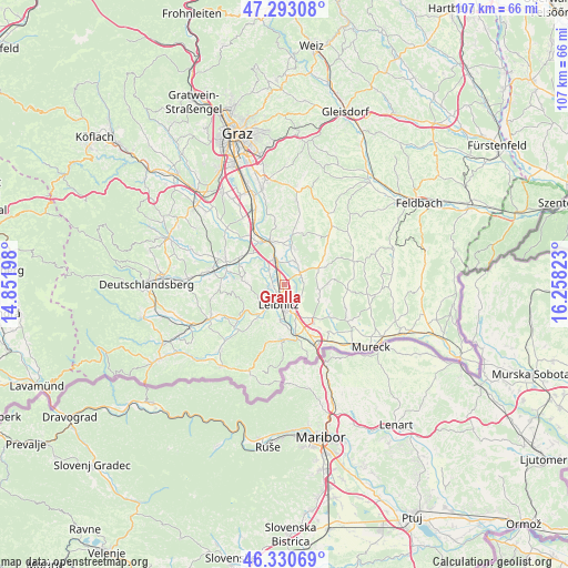
Gralla GPS coordinates[2]
46° 48' 50.544" North, 15° 33' 18.36" East
| Map corner | latitude | longitude |
|---|---|---|
| Upper-left | 47.29308°, | 14.85198° |
| Center: | 46.81404°, | 15.5551° |
| Lower-right: | 46.33069°, | 16.25823° |
| Map W x H: | 107×107 km | = 66.5×66.5mi |
| max Lat: | 48.98333° ⇑91.3% North |
| Gralla: | 46.81404° |
| min Lat: | ⇓8.7% South 46.48841° |
| min Long | Gralla | max Long |
| 9.57802° | 15.5551° | 17.1° |
| W 67%⇐ | ⇒33% E |
Elevation
Elevation of Gralla is 278 m = 912 ft, and this is 227.5 m = 746 ft below average elevation for this country.
| Max E: |
2140 m = 7021 ft | 79.2% |
| Avg. | 505.5 m = 1658 ft | |
| Gralla | 278 m = 912 ft | |
Min E: |
118 m = 387 ft | 20.8% |
See also: Austria elevation on elevation.city.
Geographical zone
Gralla is located in North temperate zone (between Tropic of Cancer and the Arctic Circle). Distance of this North polar circle is 2195.9 km =1364.5 mi to North.| Distance of | km | miles | from Gralla |
|---|---|---|---|
| North Pole | 4801.8 | 2983.7 | to North |
| Arctic Circle | 2195.9 | 1364.5 | to North |
| Tropic Cancer | 2599.3 | 1615.1 | to South |
| Equator | 5205.2 | 3234.4 | to South |


Nearby cities:
15 places around Gralla: (largest is in red/bold)
• Gabersdorf
4.7 km =2.9 mi,  151°
151°
• Hainsdorf im Schwarzautal
7 km =4.3 mi,  69°
69°
• Kaindorf an der Sulm
2.7 km =1.7 mi,  207°
207°
• Lang
4.6 km =2.9 mi,  304°
304°
• Lebring
4.4 km =2.7 mi,  343°
343°
• Leibnitz
3.8 km =2.4 mi,  199°
199°
• Leitring
5.3 km =3.3 mi,  170°
170°
• Neutillmitsch
1.7 km =1.1 mi,  280°
280°
• Ragnitz
3.8 km =2.4 mi,  48°
48°
• Sankt Georgen an der Stiefing
6.9 km =4.3 mi,  15°
15°
• Sankt Margarethen bei Lebring
5.9 km =3.7 mi, 339°
• Seggauberg
6 km =3.7 mi, 209°
• Tillmitsch
2.9 km =1.8 mi,  265°
265°
• Tillmitsch Links der Laßnitz
2.4 km =1.5 mi,  258°
258°
• Wagna
5.3 km =3.3 mi,  176°
176°
Sources, notices
• [Note1] Compared only with cities in Austria existing in our database
• [Src1] Map data: © OpenStreetMap contributors (CC-BY-SA)
• [Src2] Other city data from geonames.org with taken over terms of usage.
• [Src3] Geographical zone / Annual Mean Temperature by Robert A. Rohde @ Wikipedia
