Gabersdorf geodata
Gabersdorf (Styria) is a seat of a third-order administrative division; located in Austria in Europe/Vienna (GMT+2) time zone. With population of 353 people, there are 2681 cities with bigger population in this country. Compared to other cities in Austria, 92.5% of cities are located further ↑North; 68.2% of cities are located further ←West and 80.8% of cities have higher elevation than Gabersdorf. Note1
Administrative division(s):
- Level 1: Styria
- Level 2: Politischer Bezirk Leibnitz
- Level 3: Gabersdorf


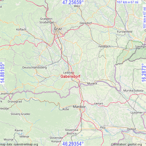
Gabersdorf GPS coordinates[2]
46° 46' 37.992" North, 15° 35' 3.012" East
| Map corner | latitude | longitude |
|---|---|---|
| Upper-left | 47.25659°, | 14.88105° |
| Center: | 46.77722°, | 15.58417° |
| Lower-right: | 46.29354°, | 16.2873° |
| Map W x H: | 107.1×107.1 km | = 66.5×66.5mi |
| max Lat: | 48.98333° ⇑92.5% North |
| Gabersdorf: | 46.77722° |
| min Lat: | ⇓7.5% South 46.48841° |
| min Long | Gabersdorf | max Long |
| 9.57802° | 15.58417° | 17.1° |
| W 68.2%⇐ | ⇒31.8% E |
Elevation
Elevation of Gabersdorf is 271 m = 889 ft, and this is 234.5 m = 769 ft below average elevation for this country.
| Max E: |
2140 m = 7021 ft | 80.8% |
| Avg. | 505.5 m = 1658 ft | |
| Gabersdorf | 271 m = 889 ft | |
Min E: |
118 m = 387 ft | 19.2% |
See also: Austria elevation on elevation.city.
Geographical zone
Gabersdorf is located in North temperate zone (between Tropic of Cancer and the Arctic Circle). Distance of this North polar circle is 2200 km =1367 mi to North.| Distance of | km | miles | from Gabersdorf |
|---|---|---|---|
| North Pole | 4805.9 | 2986.2 | to North |
| Arctic Circle | 2200 | 1367 | to North |
| Tropic Cancer | 2595.2 | 1612.6 | to South |
| Equator | 5201.1 | 3231.8 | to South |


Nearby cities:
15 places around Gabersdorf: (largest is in red/bold)
• Ehrenhausen
5.9 km =3.7 mi,  178°
178°
• Gralla
4.7 km =2.9 mi,  331°
331°
• Kaindorf an der Sulm
3.8 km =2.4 mi,  296°
296°
• Leibnitz
3.5 km =2.2 mi,  277°
277°
• Leitring
1.8 km =1.1 mi,  228°
228°
• Neutillmitsch
5.8 km =3.6 mi,  318°
318°
• Obervogau
3.6 km =2.2 mi, 179°
• Retznei
5.1 km =3.2 mi,  195°
195°
• Sankt Nikolai ob Draßling
6.2 km =3.9 mi,  55°
55°
• Sankt Veit am Vogau
6 km =3.7 mi,  132°
132°
• Seggauberg
5.3 km =3.3 mi,  257°
257°
• Straß in Steiermark
6.3 km =3.9 mi,  151°
151°
• Tillmitsch Links der Laßnitz
5.8 km =3.6 mi,  308°
308°
• Vogau
5.4 km =3.4 mi,  159°
159°
• Wagna
2.2 km =1.4 mi,  238°
238°
Sources, notices
• [Note1] Compared only with cities in Austria existing in our database
• [Src1] Map data: © OpenStreetMap contributors (CC-BY-SA)
• [Src2] Other city data from geonames.org with taken over terms of usage.
• [Src3] Geographical zone / Annual Mean Temperature by Robert A. Rohde @ Wikipedia
