Radfeld geodata
Radfeld (Tyrol) is a seat of a third-order administrative division; located in Austria in Europe/Vienna (GMT+2) time zone. With population of 2,495 people, there are 476 cities with bigger population in this country. Compared to other cities in Austria, 56.7% of cities are located further ↑North; 88.9% of cities are located further →East and 59.1% of cities have lower elevation than Radfeld. Note1


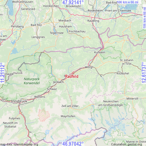
Radfeld GPS coordinates[2]
47° 26' 53.016" North, 11° 54' 51.264" East
| Map corner | latitude | longitude |
|---|---|---|
| Upper-left | 47.92141°, | 11.21112° |
| Center: | 47.44806°, | 11.91424° |
| Lower-right: | 46.97042°, | 12.61737° |
| Map W x H: | 105.7×105.7 km | = 65.7×65.7mi |
| max Lat: | 48.98333° ⇑56.7% North |
| Radfeld: | 47.44806° |
| min Lat: | ⇓43.3% South 46.48841° |
| min Long | Radfeld | max Long |
| 9.57802° | 11.91424° | 17.1° |
| W 11.1%⇐ | ⇒88.9% E |
Elevation
Elevation of Radfeld is 512 m = 1680 ft, and this is 6.5 m = 21 ft above average elevation for this country.
| Max E: |
2140 m = 7021 ft | 40.9% |
| Radfeld | 512 m 1680 ft | |
| Avg. | 505.5 m = 1658 ft | |
Min E: |
118 m = 387 ft | 59.1% |
See also: Austria elevation on elevation.city.
Geographical zone
Radfeld is located in North temperate zone (between Tropic of Cancer and the Arctic Circle). Distance of this North polar circle is 2125.4 km =1320.7 mi to North.| Distance of | km | miles | from Radfeld |
|---|---|---|---|
| North Pole | 4731.3 | 2939.9 | to North |
| Arctic Circle | 2125.4 | 1320.7 | to North |
| Tropic Cancer | 2669.8 | 1658.9 | to South |
| Equator | 5275.7 | 3278.2 | to South |


Nearby cities:
15 places around Radfeld: (largest is in red/bold)
• Alpbach
5.9 km =3.7 mi,  157°
157°
• Brandenberg
4.9 km =3 mi,  342°
342°
• Breitenbach am Inn
5.6 km =3.5 mi,  53°
53°
• Brixlegg
3.4 km =2.1 mi,  232°
232°
• Bruck am Ziller
8 km =5 mi,  216°
216°
• Kleinsöll
7.2 km =4.5 mi, 54°
• Kramsach
3 km =1.9 mi,  259°
259°
• Kundl
5.6 km =3.5 mi,  68°
68°
• Liesfeld
7 km =4.3 mi,  63°
63°
• Mariatal
3.2 km =2 mi,  269°
269°
• Mehrn
3.7 km =2.3 mi, 222°
• Münster
6.7 km =4.2 mi,  244°
244°
• Rattenberg
1.8 km =1.1 mi, 237°
• Reith im Alpbachtal
4.4 km =2.7 mi, 218°
• Voldöpp
2.3 km =1.4 mi, 260°
Sources, notices
• [Note1] Compared only with cities in Austria existing in our database
• [Src1] Map data: © OpenStreetMap contributors (CC-BY-SA)
• [Src2] Other city data from geonames.org with taken over terms of usage.
• [Src3] Geographical zone / Annual Mean Temperature by Robert A. Rohde @ Wikipedia
