Liesfeld geodata
Liesfeld (Tyrol) is a populated place; located in Austria in Europe/Vienna (GMT+2) time zone. With population of 636 people, there are 2018 cities with bigger population in this country. Compared to other cities in Austria, 55.1% of cities are located further ↑North; 88.7% of cities are located further →East and 59.3% of cities have lower elevation than Liesfeld. Note1


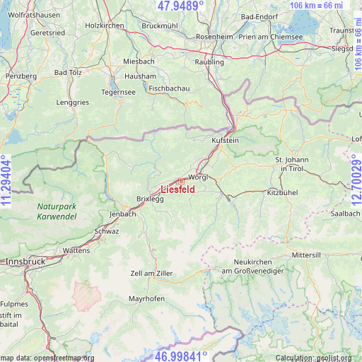
Liesfeld GPS coordinates[2]
47° 28' 32.88" North, 11° 59' 49.776" East
| Map corner | latitude | longitude |
|---|---|---|
| Upper-left | 47.9489°, | 11.29404° |
| Center: | 47.4758°, | 11.99716° |
| Lower-right: | 46.99841°, | 12.70029° |
| Map W x H: | 105.7×105.7 km | = 65.7×65.7mi |
| max Lat: | 48.98333° ⇑55.1% North |
| Liesfeld: | 47.4758° |
| min Lat: | ⇓44.9% South 46.48841° |
| min Long | Liesfeld | max Long |
| 9.57802° | 11.99716° | 17.1° |
| W 11.3%⇐ | ⇒88.7% E |
Elevation
Elevation of Liesfeld is 514 m = 1686 ft, and this is 8.5 m = 28 ft above average elevation for this country.
| Max E: |
2140 m = 7021 ft | 40.7% |
| Liesfeld | 514 m 1686 ft | |
| Avg. | 505.5 m = 1658 ft | |
Min E: |
118 m = 387 ft | 59.3% |
See also: Austria elevation on elevation.city.
Geographical zone
Liesfeld is located in North temperate zone (between Tropic of Cancer and the Arctic Circle). Distance of this North polar circle is 2122.4 km =1318.8 mi to North.| Distance of | km | miles | from Liesfeld |
|---|---|---|---|
| North Pole | 4728.2 | 2938 | to North |
| Arctic Circle | 2122.4 | 1318.8 | to North |
| Tropic Cancer | 2672.9 | 1660.9 | to South |
| Equator | 5278.8 | 3280.1 | to South |


Nearby cities:
15 places around Liesfeld: (largest is in red/bold)
• Angath
6.2 km =3.9 mi,  55°
55°
• Angerberg
4.2 km =2.6 mi,  37°
37°
• Brandenberg
7.9 km =4.9 mi,  281°
281°
• Breitenbach am Inn
1.8 km =1.1 mi, 278°
• Kirchbichl
8.8 km =5.5 mi, 58°
• Kleinsöll
1.1 km =0.7 mi,  339°
339°
• Kundl
1.5 km =0.9 mi,  225°
225°
• Mariastein
7.2 km =4.5 mi, 36°
• Niederau
7.1 km =4.4 mi,  113°
113°
• Oberau
5.3 km =3.3 mi,  132°
132°
• Oberlangkampfen
8.5 km =5.3 mi,  53°
53°
• Radfeld
7 km =4.3 mi,  243°
243°
• Rattenberg
8.7 km =5.4 mi, 242°
• Wildschönau
8.3 km =5.2 mi,  158°
158°
• Wörgl
5.1 km =3.2 mi,  73°
73°
Sources, notices
• [Note1] Compared only with cities in Austria existing in our database
• [Src1] Map data: © OpenStreetMap contributors (CC-BY-SA)
• [Src2] Other city data from geonames.org with taken over terms of usage.
• [Src3] Geographical zone / Annual Mean Temperature by Robert A. Rohde @ Wikipedia
