Brixlegg geodata
Brixlegg (Tyrol) is a seat of a third-order administrative division; located in Austria in Europe/Vienna (GMT+2) time zone. With population of 1,892 people, there are 656 cities with bigger population in this country. Compared to other cities in Austria, 57.7% of cities are located further ↑North; 89.3% of cities are located further →East and 62.3% of cities have lower elevation than Brixlegg. Note1


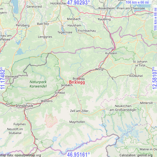
Brixlegg GPS coordinates[2]
47° 25' 45.912" North, 11° 52' 40.584" East
| Map corner | latitude | longitude |
|---|---|---|
| Upper-left | 47.90293°, | 11.17482° |
| Center: | 47.42942°, | 11.87794° |
| Lower-right: | 46.95161°, | 12.58107° |
| Map W x H: | 105.8×105.8 km | = 65.7×65.7mi |
| max Lat: | 48.98333° ⇑57.7% North |
| Brixlegg: | 47.42942° |
| min Lat: | ⇓42.3% South 46.48841° |
| min Long | Brixlegg | max Long |
| 9.57802° | 11.87794° | 17.1° |
| W 10.7%⇐ | ⇒89.3% E |
Elevation
Elevation of Brixlegg is 534 m = 1752 ft, and this is 28.5 m = 94 ft above average elevation for this country.
| Max E: |
2140 m = 7021 ft | 37.7% |
| Brixlegg | 534 m 1752 ft | |
| Avg. | 505.5 m = 1658 ft | |
Min E: |
118 m = 387 ft | 62.3% |
See also: Austria elevation on elevation.city.
Geographical zone
Brixlegg is located in North temperate zone (between Tropic of Cancer and the Arctic Circle). Distance of this North polar circle is 2127.5 km =1322 mi to North.| Distance of | km | miles | from Brixlegg |
|---|---|---|---|
| North Pole | 4733.4 | 2941.2 | to North |
| Arctic Circle | 2127.5 | 1322 | to North |
| Tropic Cancer | 2667.7 | 1657.6 | to South |
| Equator | 5273.7 | 3276.9 | to South |


Nearby cities:
15 places around Brixlegg: (largest is in red/bold)
• Alpbach
6 km =3.7 mi,  124°
124°
• Brandenberg
6.9 km =4.3 mi,  10°
10°
• Bruck am Ziller
4.8 km =3 mi,  204°
204°
• Kramsach
1.5 km =0.9 mi,  352°
352°
• Mariatal
2.1 km =1.3 mi, 347°
• Mehrn
0.7 km =0.4 mi,  160°
160°
• Münster
3.4 km =2.1 mi,  255°
255°
• Radfeld
3.4 km =2.1 mi,  52°
52°
• Rattenberg
1.6 km =1 mi, 47°
• Reith im Alpbachtal
1.4 km =0.9 mi,  180°
180°
• Rofansiedlung
6 km =3.7 mi,  248°
248°
• Schlitters
6.2 km =3.9 mi,  208°
208°
• Strass im Zillertal
5.8 km =3.6 mi,  229°
229°
• Voldöpp
1.7 km =1.1 mi, 13°
• Wiesing
6.7 km =4.2 mi, 245°
Sources, notices
• [Note1] Compared only with cities in Austria existing in our database
• [Src1] Map data: © OpenStreetMap contributors (CC-BY-SA)
• [Src2] Other city data from geonames.org with taken over terms of usage.
• [Src3] Geographical zone / Annual Mean Temperature by Robert A. Rohde @ Wikipedia
