Pram geodata
Pram (Upper Austria) is a seat of a third-order administrative division; located in Austria in Europe/Vienna (GMT+2) time zone. With population of 660 people, there are 1958 cities with bigger population in this country. Compared to other cities in Austria, 81.9% of cities are located further ↓South; 73.5% of cities are located further →East and 53% of cities have higher elevation than Pram. Note1
Administrative division(s):
- Level 1: Upper Austria
- Level 2: Politischer Bezirk Grieskirchen
- Level 3: Pram


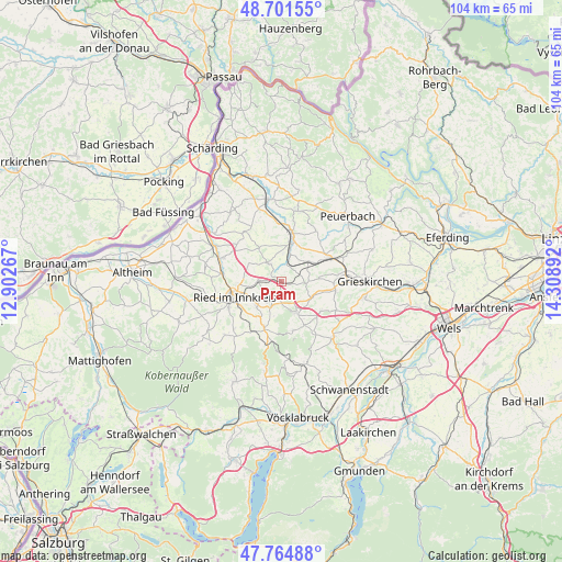
Pram GPS coordinates[2]
48° 14' 7.296" North, 13° 36' 20.844" East
| Map corner | latitude | longitude |
|---|---|---|
| Upper-left | 48.70155°, | 12.90267° |
| Center: | 48.23536°, | 13.60579° |
| Lower-right: | 47.76488°, | 14.30892° |
| Map W x H: | 104.1×104.1 km | = 64.7×64.7mi |
| max Lat: | 48.98333° ⇑18.1% North |
| Pram: | 48.23536° |
| min Lat: | ⇓81.9% South 46.48841° |
| min Long | Pram | max Long |
| 9.57802° | 13.60579° | 17.1° |
| W 26.5%⇐ | ⇒73.5% E |
Elevation
Elevation of Pram is 435 m = 1427 ft, and this is 70.5 m = 231 ft below average elevation for this country.
| Max E: |
2140 m = 7021 ft | 53% |
| Avg. | 505.5 m = 1658 ft | |
| Pram | 435 m = 1427 ft | |
Min E: |
118 m = 387 ft | 47% |
See also: Austria elevation on elevation.city.
Geographical zone
Pram is located in North temperate zone (between Tropic of Cancer and the Arctic Circle). Distance of this North polar circle is 2037.9 km =1266.3 mi to North.| Distance of | km | miles | from Pram |
|---|---|---|---|
| North Pole | 4643.8 | 2885.5 | to North |
| Arctic Circle | 2037.9 | 1266.3 | to North |
| Tropic Cancer | 2757.4 | 1713.4 | to South |
| Equator | 5363.3 | 3332.6 | to South |


Nearby cities:
15 places around Pram: (largest is in red/bold)
• Eberschwang
9.5 km =5.9 mi,  199°
199°
• Geboltskirchen
9.3 km =5.8 mi,  167°
167°
• Haag am Hausruck
6.3 km =3.9 mi,  153°
153°
• Hofkirchen an der Trattnach
10 km =6.2 mi,  99°
99°
• Kallham
9.5 km =5.9 mi,  54°
54°
• Maierhof
9.2 km =5.7 mi, 197°
• Maierhof
10.5 km =6.5 mi,  274°
274°
• Neumarkt im Hausruckkreis
10 km =6.2 mi,  65°
65°
• Ried im Innkreis
9.1 km =5.7 mi,  252°
252°
• Taiskirchen im Innkreis
4.1 km =2.5 mi,  323°
323°
• Taufkirchen an der Trattnach
10.6 km =6.6 mi,  82°
82°
• Tumeltsham
8 km =5 mi, 267°
• Weibern
9.1 km =5.7 mi,  129°
129°
• Wendling
4.5 km =2.8 mi, 95°
• Zell an der Pram
9.2 km =5.7 mi,  10°
10°
Sources, notices
• [Note1] Compared only with cities in Austria existing in our database
• [Src1] Map data: © OpenStreetMap contributors (CC-BY-SA)
• [Src2] Other city data from geonames.org with taken over terms of usage.
• [Src3] Geographical zone / Annual Mean Temperature by Robert A. Rohde @ Wikipedia
