Kallham geodata
Kallham (Upper Austria) is a populated place; located in Austria in Europe/Vienna (GMT+2) time zone. With population of 563 people, there are 2274 cities with bigger population in this country. Compared to other cities in Austria, 85.1% of cities are located further ↓South; 71.2% of cities are located further →East and 58% of cities have higher elevation than Kallham. Note1
Administrative division(s):
- Level 1: Upper Austria
- Level 2: Politischer Bezirk Grieskirchen
- Level 3: Kallham


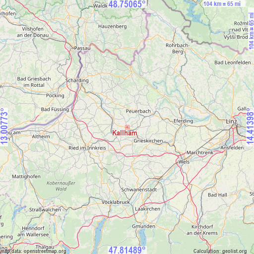
Kallham GPS coordinates[2]
48° 17' 5.676" North, 13° 42' 39.06" East
| Map corner | latitude | longitude |
|---|---|---|
| Upper-left | 48.75065°, | 13.00773° |
| Center: | 48.28491°, | 13.71085° |
| Lower-right: | 47.81489°, | 14.41398° |
| Map W x H: | 104×104 km | = 64.6×64.6mi |
| max Lat: | 48.98333° ⇑14.9% North |
| Kallham: | 48.28491° |
| min Lat: | ⇓85.1% South 46.48841° |
| min Long | Kallham | max Long |
| 9.57802° | 13.71085° | 17.1° |
| W 28.8%⇐ | ⇒71.2% E |
Elevation
Elevation of Kallham is 398 m = 1306 ft, and this is 107.5 m = 353 ft below average elevation for this country.
| Max E: |
2140 m = 7021 ft | 58% |
| Avg. | 505.5 m = 1658 ft | |
| Kallham | 398 m = 1306 ft | |
Min E: |
118 m = 387 ft | 42% |
See also: Austria elevation on elevation.city.
Geographical zone
Kallham is located in North temperate zone (between Tropic of Cancer and the Arctic Circle). Distance of this North polar circle is 2032.4 km =1262.9 mi to North.| Distance of | km | miles | from Kallham |
|---|---|---|---|
| North Pole | 4638.3 | 2882.1 | to North |
| Arctic Circle | 2032.4 | 1262.9 | to North |
| Tropic Cancer | 2762.9 | 1716.8 | to South |
| Equator | 5368.8 | 3336 | to South |


Nearby cities:
15 places around Kallham: (largest is in red/bold)
• Aistersheim
11.1 km =6.9 mi,  168°
168°
• Gallspach
11.1 km =6.9 mi,  138°
138°
• Grieskirchen
10.7 km =6.6 mi,  122°
122°
• Hofkirchen an der Trattnach
7.5 km =4.7 mi,  163°
163°
• Michaelnbach
8.9 km =5.5 mi,  87°
87°
• Neumarkt im Hausruckkreis
1.9 km =1.2 mi, 136°
• Peuerbach
8.1 km =5 mi,  33°
33°
• Pram
9.5 km =5.9 mi,  234°
234°
• Pötting
4.4 km =2.7 mi, 92°
• Raab
8.9 km =5.5 mi,  327°
327°
• Taiskirchen im Innkreis
10.4 km =6.5 mi,  257°
257°
• Taufkirchen an der Trattnach
5 km =3.1 mi,  146°
146°
• Tolleterau
7.9 km =4.9 mi, 136°
• Wendling
6.8 km =4.2 mi,  209°
209°
• Zell an der Pram
7 km =4.3 mi,  299°
299°
Sources, notices
• [Note1] Compared only with cities in Austria existing in our database
• [Src1] Map data: © OpenStreetMap contributors (CC-BY-SA)
• [Src2] Other city data from geonames.org with taken over terms of usage.
• [Src3] Geographical zone / Annual Mean Temperature by Robert A. Rohde @ Wikipedia
