Hofkirchen an der Trattnach geodata
Hofkirchen an der Trattnach (Upper Austria) is a populated place; located in Austria in Europe/Vienna (GMT+2) time zone. With population of 758 people, there are 1710 cities with bigger population in this country. Compared to other cities in Austria, 80.8% of cities are located further ↓South; 70.6% of cities are located further →East and 59.6% of cities have higher elevation than Hofkirchen an der Trattnach. Note1
Administrative division(s):
- Level 1: Upper Austria
- Level 2: Politischer Bezirk Grieskirchen
- Level 3: Hofkirchen an der Trattnach
Current local time in Hofkirchen an der Trattnach:
09:20 PM, FridayDifference from your time zone: hours


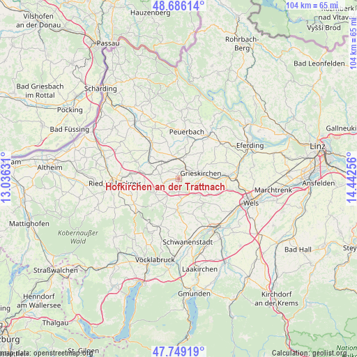
Hofkirchen an der Trattnach GPS coordinates[2]
48° 13' 11.316" North, 13° 44' 21.948" East
| Map corner | latitude | longitude |
|---|---|---|
| Upper-left | 48.68614°, | 13.03631° |
| Center: | 48.21981°, | 13.73943° |
| Lower-right: | 47.74919°, | 14.44256° |
| Map W x H: | 104.2×104.2 km | = 64.7×64.7mi |
| max Lat: | 48.98333° ⇑19.2% North |
| Hofkirchen an der Trattnach: | 48.21981° |
| min Lat: | ⇓80.8% South 46.48841° |
| min Long | Hofkirchen an d | max Long |
| 9.57802° | 13.73943° | 17.1° |
| W 29.4%⇐ | ⇒70.6% E |
Elevation
Elevation of Hofkirchen an der Trattnach is 386 m = 1266 ft, and this is 119.5 m = 392 ft below average elevation for this country.
| Max E: |
2140 m = 7021 ft | 59.6% |
| Avg. | 505.5 m = 1658 ft | |
| Hofkirchen an der Trattnach | 386 m = 1266 ft | |
Min E: |
118 m = 387 ft | 40.4% |
See also: Austria elevation on elevation.city.
Geographical zone
Hofkirchen an der Trattnach is located in North temperate zone (between Tropic of Cancer and the Arctic Circle). Distance of this North polar circle is 2039.6 km =1267.3 mi to North.| Distance of | km | miles | from Hofkirchen an der Trattnach |
|---|---|---|---|
| North Pole | 4645.5 | 2886.6 | to North |
| Arctic Circle | 2039.6 | 1267.3 | to North |
| Tropic Cancer | 2755.6 | 1712.2 | to South |
| Equator | 5361.5 | 3331.5 | to South |


Nearby cities:
15 places around Hofkirchen an der Trattnach: (largest is in red/bold)
• Aistersheim
3.7 km =2.3 mi,  177°
177°
• Gallspach
5.3 km =3.3 mi,  101°
101°
• Gaspoltshofen
8.5 km =5.3 mi, 181°
• Grieskirchen
7.1 km =4.4 mi,  77°
77°
• Haag am Hausruck
8.1 km =5 mi,  240°
240°
• Kallham
7.5 km =4.7 mi,  343°
343°
• Meggenhofen
6.1 km =3.8 mi,  136°
136°
• Neumarkt im Hausruckkreis
5.9 km =3.7 mi,  352°
352°
• Pram
10 km =6.2 mi,  279°
279°
• Pötting
7.4 km =4.6 mi,  18°
18°
• Schlüsslberg
9.8 km =6.1 mi,  90°
90°
• Taufkirchen an der Trattnach
3.1 km =1.9 mi,  11°
11°
• Tolleterau
3.6 km =2.2 mi,  65°
65°
• Weibern
5 km =3.1 mi,  215°
215°
• Wendling
5.6 km =3.5 mi, 283°
Sources, notices
• [Note1] Compared only with cities in Austria existing in our database
• [Src1] Map data: © OpenStreetMap contributors (CC-BY-SA)
• [Src2] Other city data from geonames.org with taken over terms of usage.
• [Src3] Geographical zone / Annual Mean Temperature by Robert A. Rohde @ Wikipedia
