Pottschach geodata
Pottschach (Lower Austria) is a populated place; located in Austria in Europe/Vienna (GMT+2) time zone. With population of 4,826 people, there are 200 cities with bigger population in this country. Compared to other cities in Austria, 53.3% of cities are located further ↓South; 80.4% of cities are located further ←West and 57.4% of cities have higher elevation than Pottschach. Note1
Administrative division(s):
- Level 1: Lower Austria
- Level 2: Politischer Bezirk Neunkirchen
- Level 3: Ternitz


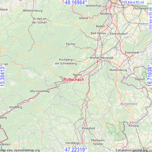
Pottschach GPS coordinates[2]
47° 41' 54.816" North, 16° 0' 26.1" East
| Map corner | latitude | longitude |
|---|---|---|
| Upper-left | 48.16964°, | 15.30413° |
| Center: | 47.69856°, | 16.00725° |
| Lower-right: | 47.22319°, | 16.71038° |
| Map W x H: | 105.2×105.2 km | = 65.4×65.4mi |
| max Lat: | 48.98333° ⇑46.7% North |
| Pottschach: | 47.69856° |
| min Lat: | ⇓53.3% South 46.48841° |
| min Long | Pottschach | max Long |
| 9.57802° | 16.00725° | 17.1° |
| W 80.4%⇐ | ⇒19.6% E |
Elevation
Elevation of Pottschach is 402 m = 1319 ft, and this is 103.5 m = 340 ft below average elevation for this country.
| Max E: |
2140 m = 7021 ft | 57.4% |
| Avg. | 505.5 m = 1658 ft | |
| Pottschach | 402 m = 1319 ft | |
Min E: |
118 m = 387 ft | 42.6% |
See also: Austria elevation on elevation.city.
Geographical zone
Pottschach is located in North temperate zone (between Tropic of Cancer and the Arctic Circle). Distance of this North polar circle is 2097.6 km =1303.4 mi to North.| Distance of | km | miles | from Pottschach |
|---|---|---|---|
| North Pole | 4703.5 | 2922.6 | to North |
| Arctic Circle | 2097.6 | 1303.4 | to North |
| Tropic Cancer | 2697.7 | 1676.3 | to South |
| Equator | 5303.6 | 3295.5 | to South |


Nearby cities:
15 places around Pottschach: (largest is in red/bold)
• Altendorf
5.4 km =3.4 mi,  172°
172°
• Buchbach
1.7 km =1.1 mi,  262°
262°
• Enzenreith
5.3 km =3.3 mi,  230°
230°
• Gloggnitz
5.8 km =3.6 mi,  242°
242°
• Grafenbach
2.1 km =1.3 mi,  180°
180°
• Natschbach
6.9 km =4.3 mi,  78°
78°
• Neunkirchen
6.1 km =3.8 mi,  65°
65°
• Prigglitz
6 km =3.7 mi,  274°
274°
• Putzmannsdorf
1.1 km =0.7 mi, 227°
• Raglitz
6.6 km =4.1 mi,  29°
29°
• Sankt Valentin-Landschach
1.8 km =1.1 mi,  157°
157°
• Stuppach
3.8 km =2.4 mi, 237°
• Ternitz
2.9 km =1.8 mi,  48°
48°
• Wartmannstetten
5.1 km =3.2 mi,  96°
96°
• Wimpassing im Schwarzatale
2 km =1.2 mi, 75°
Sources, notices
• [Note1] Compared only with cities in Austria existing in our database
• [Src1] Map data: © OpenStreetMap contributors (CC-BY-SA)
• [Src2] Other city data from geonames.org with taken over terms of usage.
• [Src3] Geographical zone / Annual Mean Temperature by Robert A. Rohde @ Wikipedia
