Pasching geodata
Pasching (Upper Austria) is a populated place; located in Austria in Europe/Vienna (GMT+2) time zone. With population of 2,409 people, there are 500 cities with bigger population in this country. Compared to other cities in Austria, 83.4% of cities are located further ↓South; 60.4% of cities are located further →East and 76.4% of cities have higher elevation than Pasching. Note1
Administrative division(s):
- Level 1: Upper Austria
- Level 2: Politischer Bezirk Linz-Land
- Level 3: Pasching


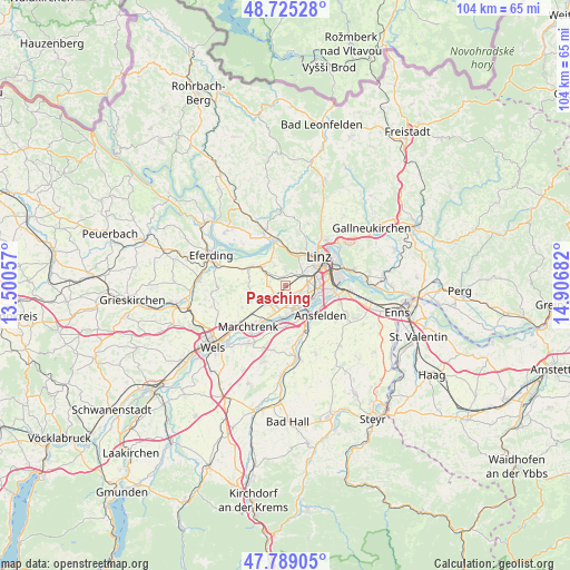
Pasching GPS coordinates[2]
48° 15' 33.516" North, 14° 12' 13.284" East
| Map corner | latitude | longitude |
|---|---|---|
| Upper-left | 48.72528°, | 13.50057° |
| Center: | 48.25931°, | 14.20369° |
| Lower-right: | 47.78905°, | 14.90682° |
| Map W x H: | 104.1×104.1 km | = 64.7×64.7mi |
| max Lat: | 48.98333° ⇑16.6% North |
| Pasching: | 48.25931° |
| min Lat: | ⇓83.4% South 46.48841° |
| min Long | Pasching | max Long |
| 9.57802° | 14.20369° | 17.1° |
| W 39.6%⇐ | ⇒60.4% E |
Elevation
Elevation of Pasching is 294 m = 965 ft, and this is 211.5 m = 694 ft below average elevation for this country.
| Max E: |
2140 m = 7021 ft | 76.4% |
| Avg. | 505.5 m = 1658 ft | |
| Pasching | 294 m = 965 ft | |
Min E: |
118 m = 387 ft | 23.6% |
See also: Austria elevation on elevation.city.
Geographical zone
Pasching is located in North temperate zone (between Tropic of Cancer and the Arctic Circle). Distance of this North polar circle is 2035.2 km =1264.6 mi to North.| Distance of | km | miles | from Pasching |
|---|---|---|---|
| North Pole | 4641.1 | 2883.8 | to North |
| Arctic Circle | 2035.2 | 1264.6 | to North |
| Tropic Cancer | 2760 | 1715 | to South |
| Equator | 5365.9 | 3334.2 | to South |


Nearby cities:
15 places around Pasching: (largest is in red/bold)
• Bergham
3.2 km =2 mi,  39°
39°
• Doppl
3.9 km =2.4 mi,  108°
108°
• Dörnbach
2.6 km =1.6 mi,  0°
0°
• Hart
4 km =2.5 mi,  80°
80°
• Hitzing
1.7 km =1.1 mi,  348°
348°
• Hörsching
4.1 km =2.5 mi,  207°
207°
• Kinderdorf Sankt Isidor
4.6 km =2.9 mi, 83°
• Langholzfeld
3.7 km =2.3 mi,  119°
119°
• Leonding
4.3 km =2.7 mi,  58°
58°
• Reith
3.1 km =1.9 mi, 76°
• Reith
4.1 km =2.5 mi,  330°
330°
• Rufling
2.3 km =1.4 mi,  24°
24°
• Thening
2.7 km =1.7 mi,  260°
260°
• Traun
4.3 km =2.7 mi,  147°
147°
• Wagram
3 km =1.9 mi,  140°
140°
Sources, notices
• [Note1] Compared only with cities in Austria existing in our database
• [Src1] Map data: © OpenStreetMap contributors (CC-BY-SA)
• [Src2] Other city data from geonames.org with taken over terms of usage.
• [Src3] Geographical zone / Annual Mean Temperature by Robert A. Rohde @ Wikipedia
