Otterthal geodata
Otterthal (Lower Austria) is a seat of a third-order administrative division; located in Austria in Europe/Vienna (GMT+2) time zone. With population of 592 people, there are 2162 cities with bigger population in this country. Compared to other cities in Austria, 51.1% of cities are located further ↓South; 78.3% of cities are located further ←West and 78.2% of cities have lower elevation than Otterthal. Note1
Administrative division(s):
- Level 1: Lower Austria
- Level 2: Politischer Bezirk Neunkirchen
- Level 3: Otterthal


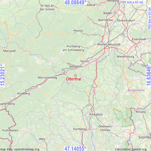
Otterthal GPS coordinates[2]
47° 37' 0.012" North, 15° 55' 59.988" East
| Map corner | latitude | longitude |
|---|---|---|
| Upper-left | 48.08849°, | 15.23021° |
| Center: | 47.61667°, | 15.93333° |
| Lower-right: | 47.14055°, | 16.63646° |
| Map W x H: | 105.4×105.4 km | = 65.5×65.5mi |
| max Lat: | 48.98333° ⇑48.9% North |
| Otterthal: | 47.61667° |
| min Lat: | ⇓51.1% South 46.48841° |
| min Long | Otterthal | max Long |
| 9.57802° | 15.93333° | 17.1° |
| W 78.3%⇐ | ⇒21.7% E |
Elevation
Elevation of Otterthal is 689 m = 2260 ft, and this is 183.5 m = 602 ft above average elevation for this country.
| Max E: |
2140 m = 7021 ft | 21.8% |
| Otterthal | 689 m 2260 ft | |
| Avg. | 505.5 m = 1658 ft | |
Min E: |
118 m = 387 ft | 78.2% |
See also: Austria elevation on elevation.city.
Geographical zone
Otterthal is located in North temperate zone (between Tropic of Cancer and the Arctic Circle). Distance of this North polar circle is 2106.7 km =1309 mi to North.| Distance of | km | miles | from Otterthal |
|---|---|---|---|
| North Pole | 4712.6 | 2928.3 | to North |
| Arctic Circle | 2106.7 | 1309 | to North |
| Tropic Cancer | 2688.6 | 1670.6 | to South |
| Equator | 5294.5 | 3289.8 | to South |


Nearby cities:
15 places around Otterthal: (largest is in red/bold)
• Altendorf
7.3 km =4.5 mi,  59°
59°
• Buchbach
9.7 km =6 mi,  23°
23°
• Enzenreith
5.9 km =3.7 mi,  14°
14°
• Feistritz am Wechsel
8.9 km =5.5 mi,  101°
101°
• Gloggnitz
6.5 km =4 mi,  3°
3°
• Grafenbach
9 km =5.6 mi,  38°
38°
• Kirchberg am Wechsel
4.4 km =2.7 mi, 103°
• Prigglitz
9.6 km =6 mi,  357°
357°
• Putzmannsdorf
9.6 km =6 mi,  29°
29°
• Raach am Hochgebirge
1.9 km =1.2 mi, 0°
• Sankt Corona am Wechsel
6.2 km =3.9 mi,  126°
126°
• Schottwien
6.4 km =4 mi,  314°
314°
• Semmering
8 km =5 mi,  283°
283°
• Stuppach
7.5 km =4.7 mi, 18°
• Trattenbach
5.3 km =3.3 mi,  249°
249°
Sources, notices
• [Note1] Compared only with cities in Austria existing in our database
• [Src1] Map data: © OpenStreetMap contributors (CC-BY-SA)
• [Src2] Other city data from geonames.org with taken over terms of usage.
• [Src3] Geographical zone / Annual Mean Temperature by Robert A. Rohde @ Wikipedia
