Grosshöflein geodata
Grosshöflein (Burgenland) is a populated place; located in Austria in Europe/Vienna (GMT+2) time zone. With population of 2,048 people, there are 597 cities with bigger population in this country. Compared to other cities in Austria, 58.3% of cities are located further ↓South; 93.4% of cities are located further ←West and 90.1% of cities have higher elevation than Grosshöflein. Note1


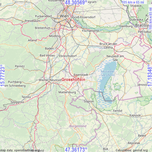
Grosshöflein GPS coordinates[2]
47° 50' 9.096" North, 16° 28' 49.26" East
| Map corner | latitude | longitude |
|---|---|---|
| Upper-left | 48.30569°, | 15.77723° |
| Center: | 47.83586°, | 16.48035° |
| Lower-right: | 47.36173°, | 17.18348° |
| Map W x H: | 105×105 km | = 65.2×65.2mi |
| max Lat: | 48.98333° ⇑41.7% North |
| Grosshöflein: | 47.83586° |
| min Lat: | ⇓58.3% South 46.48841° |
| min Long | Grosshöflein | max Long |
| 9.57802° | 16.48035° | 17.1° |
| W 93.4%⇐ | ⇒6.6% E |
Elevation
Elevation of Grosshöflein is 212 m = 696 ft, and this is 293.5 m = 963 ft below average elevation for this country.
| Max E: |
2140 m = 7021 ft | 90.1% |
| Avg. | 505.5 m = 1658 ft | |
| Grosshöflein | 212 m = 696 ft | |
Min E: |
118 m = 387 ft | 9.9% |
See also: Austria elevation on elevation.city.
Geographical zone
Grosshöflein is located in North temperate zone (between Tropic of Cancer and the Arctic Circle). Distance of this North polar circle is 2082.3 km =1293.9 mi to North.| Distance of | km | miles | from Grosshöflein |
|---|---|---|---|
| North Pole | 4688.2 | 2913.1 | to North |
| Arctic Circle | 2082.3 | 1293.9 | to North |
| Tropic Cancer | 2712.9 | 1685.7 | to South |
| Equator | 5318.8 | 3304.9 | to South |


Nearby cities:
15 places around Grosshöflein: (largest is in red/bold)
• Antau
6.9 km =4.3 mi,  180°
180°
• Eisenstadt
3.4 km =2.1 mi,  71°
71°
• Hirm
5.8 km =3.6 mi,  199°
199°
• Hornstein
5.6 km =3.5 mi,  331°
331°
• Kleinhöflein im Burgenland
1.9 km =1.2 mi, 70°
• Krensdorf
7.4 km =4.6 mi,  221°
221°
• Müllendorf
1.4 km =0.9 mi,  286°
286°
• Sankt Georgen am Leithagebirge
5.4 km =3.4 mi, 73°
• Siegendorf im Burgenland
7.7 km =4.8 mi,  142°
142°
• Steinbrunn
4.8 km =3 mi,  266°
266°
• Stöttera
7.7 km =4.8 mi,  190°
190°
• Trausdorf an der Wulka
6.3 km =3.9 mi,  113°
113°
• Wulkaprodersdorf
4.6 km =2.9 mi,  157°
157°
• Zillingdorf-Bergwerk
7.4 km =4.6 mi,  276°
276°
• Zillingtal
5.8 km =3.6 mi,  245°
245°
Sources, notices
• [Note1] Compared only with cities in Austria existing in our database
• [Src1] Map data: © OpenStreetMap contributors (CC-BY-SA)
• [Src2] Other city data from geonames.org with taken over terms of usage.
• [Src3] Geographical zone / Annual Mean Temperature by Robert A. Rohde @ Wikipedia
