Angath geodata
Angath (Tyrol) is a seat of a third-order administrative division; located in Austria in Europe/Vienna (GMT+2) time zone. With population of 1,008 people, there are 1281 cities with bigger population in this country. Compared to other cities in Austria, 53.4% of cities are located further ↑North; 88.4% of cities are located further →East and 57.1% of cities have lower elevation than Angath. Note1


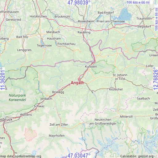
Angath GPS coordinates[2]
47° 30' 27.288" North, 12° 3' 54.468" East
| Map corner | latitude | longitude |
|---|---|---|
| Upper-left | 47.98039°, | 11.36201° |
| Center: | 47.50758°, | 12.06513° |
| Lower-right: | 47.03047°, | 12.76826° |
| Map W x H: | 105.6×105.6 km | = 65.6×65.6mi |
| max Lat: | 48.98333° ⇑53.4% North |
| Angath: | 47.50758° |
| min Lat: | ⇓46.6% South 46.48841° |
| min Long | Angath | max Long |
| 9.57802° | 12.06513° | 17.1° |
| W 11.6%⇐ | ⇒88.4% E |
Elevation
Elevation of Angath is 499 m = 1637 ft, and this is 6.5 m = 21 ft below average elevation for this country.
| Max E: |
2140 m = 7021 ft | 42.9% |
| Avg. | 505.5 m = 1658 ft | |
| Angath | 499 m = 1637 ft | |
Min E: |
118 m = 387 ft | 57.1% |
See also: Austria elevation on elevation.city.
Geographical zone
Angath is located in North temperate zone (between Tropic of Cancer and the Arctic Circle). Distance of this North polar circle is 2118.8 km =1316.6 mi to North.| Distance of | km | miles | from Angath |
|---|---|---|---|
| North Pole | 4724.7 | 2935.8 | to North |
| Arctic Circle | 2118.8 | 1316.6 | to North |
| Tropic Cancer | 2676.4 | 1663 | to South |
| Equator | 5282.3 | 3282.3 | to South |


Nearby cities:
15 places around Angath: (largest is in red/bold)
• Angerberg
2.6 km =1.6 mi,  265°
265°
• Bad Häring
4.1 km =2.5 mi,  85°
85°
• Grafenweg
7.2 km =4.5 mi,  153°
153°
• Itter
6.9 km =4.3 mi,  131°
131°
• Kirchbichl
2.6 km =1.6 mi,  64°
64°
• Kleinsöll
6 km =3.7 mi,  245°
245°
• Langkampfen
5.3 km =3.3 mi,  30°
30°
• Liesfeld
6.2 km =3.9 mi,  235°
235°
• Mariastein
2.4 km =1.5 mi,  340°
340°
• Niederau
6.5 km =4 mi,  167°
167°
• Niederbreitenbach
3.2 km =2 mi, 25°
• Oberlangkampfen
2.3 km =1.4 mi,  49°
49°
• Schwoich
7.1 km =4.4 mi, 52°
• Unterlangkampfen
5.4 km =3.4 mi, 29°
• Wörgl
2.1 km =1.3 mi,  187°
187°
Sources, notices
• [Note1] Compared only with cities in Austria existing in our database
• [Src1] Map data: © OpenStreetMap contributors (CC-BY-SA)
• [Src2] Other city data from geonames.org with taken over terms of usage.
• [Src3] Geographical zone / Annual Mean Temperature by Robert A. Rohde @ Wikipedia
