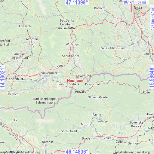
Neuhaus geodata
Neuhaus (Carinthia) is a seat of a third-order administrative division; located in Austria in Europe/Vienna (GMT+2) time zone. With population of 101 people, there are 2925 cities with bigger population in this country. Compared to other cities in Austria, 97% of cities are located further ↑North; 52.9% of cities are located further ←West and 55.4% of cities have lower elevation than Neuhaus. Note1
Administrative division(s):
- Level 1: Carinthia
- Level 2: Politischer Bezirk Völkermarkt
- Level 3: Neuhaus


Neuhaus GPS coordinates[2]
46° 37' 59.988" North, 14° 52' 59.988" East
| Map corner | latitude | longitude |
|---|---|---|
| Upper-left | 47.11399°, | 14.18021° |
| Center: | 46.63333°, | 14.88333° |
| Lower-right: | 46.14836°, | 15.58646° |
| Map W x H: | 107.4×107.4 km | = 66.7×66.7mi |
| max Lat: | 48.98333° ⇑97% North |
| Neuhaus: | 46.63333° |
| min Lat: | ⇓3% South 46.48841° |
| min Long | Neuhaus | max Long |
| 9.57802° | 14.88333° | 17.1° |
| W 52.9%⇐ | ⇒47.1% E |
Elevation
Elevation of Neuhaus is 488 m = 1601 ft, and this is 17.5 m = 57 ft below average elevation for this country.
| Max E: |
2140 m = 7021 ft | 44.6% |
| Avg. | 505.5 m = 1658 ft | |
| Neuhaus | 488 m = 1601 ft | |
Min E: |
118 m = 387 ft | 55.4% |
See also: Austria elevation on elevation.city.
Geographical zone
Neuhaus is located in North temperate zone (between Tropic of Cancer and the Arctic Circle). Distance of this North polar circle is 2216 km =1377 mi to North.| Distance of | km | miles | from Neuhaus |
|---|---|---|---|
| North Pole | 4821.9 | 2996.2 | to North |
| Arctic Circle | 2216 | 1377 | to North |
| Tropic Cancer | 2579.2 | 1602.6 | to South |
| Equator | 5185.1 | 3221.9 | to South |


Nearby cities:
15 places around Neuhaus: (largest is in red/bold)
• Bleiburg/Pliberk
8.1 km =5 mi,  233°
233°
• Ebersdorf
9.4 km =5.8 mi, 233°
• Eitweg
14.8 km =9.2 mi,  0°
0°
• Feistritz ob Bleiburg
12.9 km =8 mi,  223°
223°
• Gemmersdorf
13.2 km =8.2 mi,  11°
11°
• Griffen
13.9 km =8.6 mi,  304°
304°
• Jakling
14.4 km =8.9 mi,  348°
348°
• Lavamünd
4.9 km =3 mi,  81°
81°
• Mittlern
12.7 km =7.9 mi,  255°
255°
• Ruden
8.6 km =5.3 mi,  288°
288°
• Sankt Andrä
15.8 km =9.8 mi,  342°
342°
• Sankt Georgen
9.8 km =6.1 mi, 14°
• Sankt Michael ob Bleiburg
12.3 km =7.6 mi,  240°
240°
• Sankt Paul im Levanttal
7.5 km =4.7 mi,  355°
355°
• Soboth
15.8 km =9.8 mi,  70°
70°
Sources, notices
• [Note1] Compared only with cities in Austria existing in our database
• [Src1] Map data: © OpenStreetMap contributors (CC-BY-SA)
• [Src2] Other city data from geonames.org with taken over terms of usage.
• [Src3] Geographical zone / Annual Mean Temperature by Robert A. Rohde @ Wikipedia
