Lavamünd geodata
Lavamünd (Carinthia) is a seat of a third-order administrative division; located in Austria in Europe/Vienna (GMT+2) time zone. With population of 328 people, there are 2709 cities with bigger population in this country. Compared to other cities in Austria, 96.8% of cities are located further ↑North; 53.6% of cities are located further ←West and 65.9% of cities have higher elevation than Lavamünd. Note1
Administrative division(s):
- Level 1: Carinthia
- Level 2: Politischer Bezirk Wolfsberg
- Level 3: Lavamünd


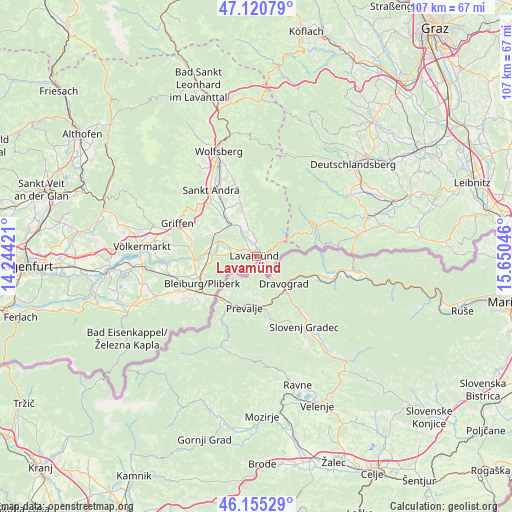
Lavamünd GPS coordinates[2]
46° 38' 24.684" North, 14° 56' 50.388" East
| Map corner | latitude | longitude |
|---|---|---|
| Upper-left | 47.12079°, | 14.24421° |
| Center: | 46.64019°, | 14.94733° |
| Lower-right: | 46.15529°, | 15.65046° |
| Map W x H: | 107.4×107.4 km | = 66.7×66.7mi |
| max Lat: | 48.98333° ⇑96.8% North |
| Lavamünd: | 46.64019° |
| min Lat: | ⇓3.2% South 46.48841° |
| min Long | Lavamünd | max Long |
| 9.57802° | 14.94733° | 17.1° |
| W 53.6%⇐ | ⇒46.4% E |
Elevation
Elevation of Lavamünd is 349 m = 1145 ft, and this is 156.5 m = 513 ft below average elevation for this country.
| Max E: |
2140 m = 7021 ft | 65.9% |
| Avg. | 505.5 m = 1658 ft | |
| Lavamünd | 349 m = 1145 ft | |
Min E: |
118 m = 387 ft | 34.1% |
See also: Austria elevation on elevation.city.
Geographical zone
Lavamünd is located in North temperate zone (between Tropic of Cancer and the Arctic Circle). Distance of this North polar circle is 2215.3 km =1376.5 mi to North.| Distance of | km | miles | from Lavamünd |
|---|---|---|---|
| North Pole | 4821.2 | 2995.8 | to North |
| Arctic Circle | 2215.3 | 1376.5 | to North |
| Tropic Cancer | 2580 | 1603.1 | to South |
| Equator | 5185.9 | 3222.4 | to South |


Nearby cities:
15 places around Lavamünd: (largest is in red/bold)
• Bleiburg/Pliberk
12.6 km =7.8 mi,  243°
243°
• Ebersdorf
14 km =8.7 mi, 243°
• Eitweg
14.9 km =9.3 mi,  340°
340°
• Feistritz ob Bleiburg
17.1 km =10.6 mi,  234°
234°
• Gemmersdorf
12.4 km =7.7 mi,  349°
349°
• Jakling
15.5 km =9.6 mi,  329°
329°
• Mittlern
17.7 km =11 mi,  257°
257°
• Neuhaus
4.9 km =3 mi, 261°
• Ruden
13.2 km =8.2 mi,  278°
278°
• Sankt Andrä
17.2 km =10.7 mi, 325°
• Sankt Georgen
9 km =5.6 mi, 344°
• Sankt Michael ob Bleiburg
17 km =10.6 mi,  246°
246°
• Sankt Oswald ob Eibiswald
17 km =10.6 mi,  63°
63°
• Sankt Paul im Levanttal
8.7 km =5.4 mi,  320°
320°
• Soboth
11 km =6.8 mi,  65°
65°
Sources, notices
• [Note1] Compared only with cities in Austria existing in our database
• [Src1] Map data: © OpenStreetMap contributors (CC-BY-SA)
• [Src2] Other city data from geonames.org with taken over terms of usage.
• [Src3] Geographical zone / Annual Mean Temperature by Robert A. Rohde @ Wikipedia
