Mühlgraben geodata
Mühlgraben (Burgenland) is a seat of a third-order administrative division; located in Austria in Europe/Vienna (GMT+2) time zone. With population of 396 people, there are 2620 cities with bigger population in this country. Compared to other cities in Austria, 88.1% of cities are located further ↑North; 81.3% of cities are located further ←West and 73% of cities have higher elevation than Mühlgraben. Note1
Administrative division(s):
- Level 1: Burgenland
- Level 2: Politischer Bezirk Jennersdorf
- Level 3: Mühlgraben


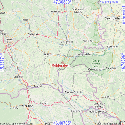
Mühlgraben GPS coordinates[2]
46° 53' 22.992" North, 16° 2' 26.988" East
| Map corner | latitude | longitude |
|---|---|---|
| Upper-left | 47.36809°, | 15.33771° |
| Center: | 46.88972°, | 16.04083° |
| Lower-right: | 46.40705°, | 16.74396° |
| Map W x H: | 106.9×106.9 km | = 66.4×66.4mi |
| max Lat: | 48.98333° ⇑88.1% North |
| Mühlgraben: | 46.88972° |
| min Lat: | ⇓11.9% South 46.48841° |
| min Long | Mühlgraben | max Long |
| 9.57802° | 16.04083° | 17.1° |
| W 81.3%⇐ | ⇒18.7% E |
Elevation
Elevation of Mühlgraben is 314 m = 1030 ft, and this is 191.5 m = 628 ft below average elevation for this country.
| Max E: |
2140 m = 7021 ft | 73% |
| Avg. | 505.5 m = 1658 ft | |
| Mühlgraben | 314 m = 1030 ft | |
Min E: |
118 m = 387 ft | 27% |
See also: Austria elevation on elevation.city.
Geographical zone
Mühlgraben is located in North temperate zone (between Tropic of Cancer and the Arctic Circle). Distance of this North polar circle is 2187.5 km =1359.2 mi to North.| Distance of | km | miles | from Mühlgraben |
|---|---|---|---|
| North Pole | 4793.4 | 2978.5 | to North |
| Arctic Circle | 2187.5 | 1359.2 | to North |
| Tropic Cancer | 2607.7 | 1620.3 | to South |
| Equator | 5213.6 | 3239.6 | to South |


Nearby cities:
15 places around Mühlgraben: (largest is in red/bold)
• Bairisch Kölldorf
8.6 km =5.3 mi,  252°
252°
• Brunn
6.9 km =4.3 mi,  344°
344°
• Fehring
6.1 km =3.8 mi, 336°
• Gossendorf
8.7 km =5.4 mi,  285°
285°
• Grieselstein
9.2 km =5.7 mi,  40°
40°
• Hatzendorf
10.1 km =6.3 mi, 342°
• Hohenbrugg an der Raab
6.9 km =4.3 mi,  19°
19°
• Jennersdorf
9.4 km =5.8 mi,  54°
54°
• Kapfenstein
5.3 km =3.3 mi,  265°
265°
• Leitersdorf im Raabtal
10 km =6.2 mi,  305°
305°
• Neuhaus am Klausenbach
2.6 km =1.6 mi,  192°
192°
• Pertlstein
8.3 km =5.2 mi, 313°
• Sankt Anna am Aigen
8.4 km =5.2 mi,  219°
219°
• Sankt Martin an der Raab
8.1 km =5 mi,  63°
63°
• Unterlamm
9.9 km =6.2 mi,  10°
10°
Sources, notices
• [Note1] Compared only with cities in Austria existing in our database
• [Src1] Map data: © OpenStreetMap contributors (CC-BY-SA)
• [Src2] Other city data from geonames.org with taken over terms of usage.
• [Src3] Geographical zone / Annual Mean Temperature by Robert A. Rohde @ Wikipedia
