Fehring geodata
Fehring (Styria) is a seat of a third-order administrative division; located in Austria in Europe/Vienna (GMT+2) time zone. With population of 1,675 people, there are 751 cities with bigger population in this country. Compared to other cities in Austria, 86.8% of cities are located further ↑North; 80.5% of cities are located further ←West and 82.8% of cities have higher elevation than Fehring. Note1
Administrative division(s):
- Level 1: Styria
- Level 2: Politischer Bezirk Südoststeiermark
- Level 3: Fehring


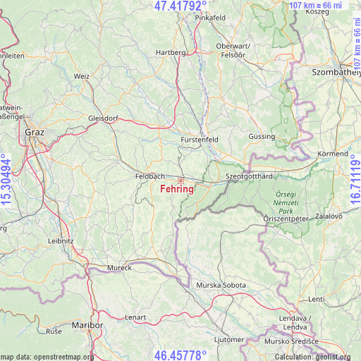
Fehring GPS coordinates[2]
46° 56' 24" North, 16° 0' 29.016" East
| Map corner | latitude | longitude |
|---|---|---|
| Upper-left | 47.41792°, | 15.30494° |
| Center: | 46.94°, | 16.00806° |
| Lower-right: | 46.45778°, | 16.71119° |
| Map W x H: | 106.8×106.8 km | = 66.4×66.4mi |
| max Lat: | 48.98333° ⇑86.8% North |
| Fehring: | 46.94° |
| min Lat: | ⇓13.2% South 46.48841° |
| min Long | Fehring | max Long |
| 9.57802° | 16.00806° | 17.1° |
| W 80.5%⇐ | ⇒19.5% E |
Elevation
Elevation of Fehring is 260 m = 853 ft, and this is 245.5 m = 805 ft below average elevation for this country.
| Max E: |
2140 m = 7021 ft | 82.8% |
| Avg. | 505.5 m = 1658 ft | |
| Fehring | 260 m = 853 ft | |
Min E: |
118 m = 387 ft | 17.2% |
See also: Austria elevation on elevation.city.
Geographical zone
Fehring is located in North temperate zone (between Tropic of Cancer and the Arctic Circle). Distance of this North polar circle is 2181.9 km =1355.8 mi to North.| Distance of | km | miles | from Fehring |
|---|---|---|---|
| North Pole | 4787.8 | 2975 | to North |
| Arctic Circle | 2181.9 | 1355.8 | to North |
| Tropic Cancer | 2613.3 | 1623.8 | to South |
| Equator | 5219.2 | 3243.1 | to South |


Nearby cities:
15 places around Fehring: (largest is in red/bold)
• Brunn
1.3 km =0.8 mi,  30°
30°
• Gossendorf
6.7 km =4.2 mi,  241°
241°
• Grieselstein
8.6 km =5.3 mi,  80°
80°
• Hatzendorf
4.1 km =2.5 mi,  352°
352°
• Hohenbrugg an der Raab
4.8 km =3 mi, 78°
• Kapfenstein
6.6 km =4.1 mi,  204°
204°
• Leitersdorf im Raabtal
5.7 km =3.5 mi,  272°
272°
• Lödersdorf
5.3 km =3.3 mi,  292°
292°
• Lödersdorf I
4.8 km =3 mi,  296°
296°
• Mühldorf bei Feldbach
7.6 km =4.7 mi, 268°
• Mühlgraben
6.1 km =3.8 mi,  156°
156°
• Neuhaus am Klausenbach
8.4 km =5.2 mi,  166°
166°
• Pertlstein
3.5 km =2.2 mi, 271°
• Raabau
7.7 km =4.8 mi, 289°
• Unterlamm
5.9 km =3.7 mi,  45°
45°
Sources, notices
• [Note1] Compared only with cities in Austria existing in our database
• [Src1] Map data: © OpenStreetMap contributors (CC-BY-SA)
• [Src2] Other city data from geonames.org with taken over terms of usage.
• [Src3] Geographical zone / Annual Mean Temperature by Robert A. Rohde @ Wikipedia
