Loretto geodata
Loretto (Burgenland) is a seat of a third-order administrative division; located in Austria in Europe/Vienna (GMT+2) time zone. With population of 475 people, there are 2534 cities with bigger population in this country. Compared to other cities in Austria, 61.7% of cities are located further ↓South; 94.4% of cities are located further ←West and 90.4% of cities have higher elevation than Loretto. Note1


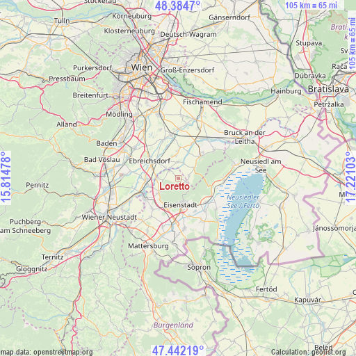
Loretto GPS coordinates[2]
47° 54' 56.124" North, 16° 31' 4.44" East
| Map corner | latitude | longitude |
|---|---|---|
| Upper-left | 48.3847°, | 15.81478° |
| Center: | 47.91559°, | 16.5179° |
| Lower-right: | 47.44219°, | 17.22103° |
| Map W x H: | 104.8×104.8 km | = 65.1×65.1mi |
| max Lat: | 48.98333° ⇑38.3% North |
| Loretto: | 47.91559° |
| min Lat: | ⇓61.7% South 46.48841° |
| min Long | Loretto | max Long |
| 9.57802° | 16.5179° | 17.1° |
| W 94.4%⇐ | ⇒5.6% E |
Elevation
Elevation of Loretto is 211 m = 692 ft, and this is 294.5 m = 966 ft below average elevation for this country.
| Max E: |
2140 m = 7021 ft | 90.4% |
| Avg. | 505.5 m = 1658 ft | |
| Loretto | 211 m = 692 ft | |
Min E: |
118 m = 387 ft | 9.6% |
See also: Austria elevation on elevation.city.
Geographical zone
Loretto is located in North temperate zone (between Tropic of Cancer and the Arctic Circle). Distance of this North polar circle is 2073.5 km =1288.4 mi to North.| Distance of | km | miles | from Loretto |
|---|---|---|---|
| North Pole | 4679.3 | 2907.6 | to North |
| Arctic Circle | 2073.5 | 1288.4 | to North |
| Tropic Cancer | 2721.8 | 1691.2 | to South |
| Equator | 5327.7 | 3310.5 | to South |


Nearby cities:
15 places around Loretto: (largest is in red/bold)
• Au am Leithaberge
3.1 km =1.9 mi,  74°
74°
• Deutschbrodersdorf
4.7 km =2.9 mi,  309°
309°
• Eisenstadt
7.8 km =4.8 mi,  177°
177°
• Hof am Leithaberge
6.2 km =3.9 mi,  51°
51°
• Hornstein
6.7 km =4.2 mi,  234°
234°
• Kleinhöflein im Burgenland
8.3 km =5.2 mi,  187°
187°
• Leithaprodersdorf
3.5 km =2.2 mi,  304°
304°
• Mannersdorf am Leithagebirge
8.3 km =5.2 mi, 47°
• Sankt Georgen am Leithagebirge
7.7 km =4.8 mi,  161°
161°
• Seibersdorf
4.8 km =3 mi,  0°
0°
• Stotzing
2.3 km =1.4 mi,  114°
114°
• Unterwaltersdorf
8.5 km =5.3 mi, 296°
• Wampersdorf
7.5 km =4.7 mi,  270°
270°
• Wasenbruck
8.5 km =5.3 mi,  20°
20°
• Wimpassing an der Leitha
6.3 km =3.9 mi, 271°
Sources, notices
• [Note1] Compared only with cities in Austria existing in our database
• [Src1] Map data: © OpenStreetMap contributors (CC-BY-SA)
• [Src2] Other city data from geonames.org with taken over terms of usage.
• [Src3] Geographical zone / Annual Mean Temperature by Robert A. Rohde @ Wikipedia
