Deutschbrodersdorf geodata
Deutschbrodersdorf (Lower Austria) is a populated place; located in Austria in Europe/Vienna (GMT+2) time zone. With population of 933 people, there are 1380 cities with bigger population in this country. Compared to other cities in Austria, 62.7% of cities are located further ↓South; 93.1% of cities are located further ←West and 93.2% of cities have higher elevation than Deutschbrodersdorf. Note1
Administrative division(s):
- Level 1: Lower Austria
- Level 2: Politischer Bezirk Baden
- Level 3: Seibersdorf


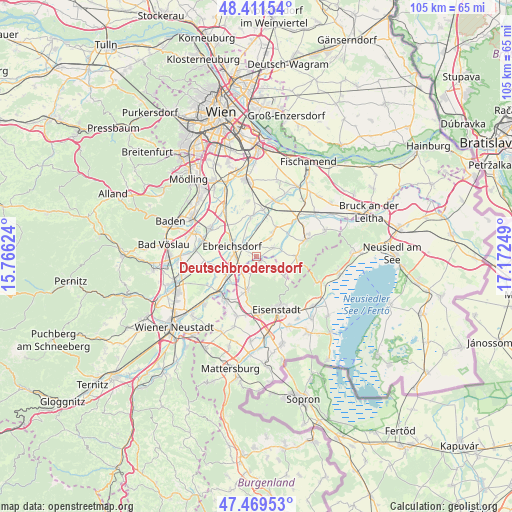
Deutschbrodersdorf GPS coordinates[2]
47° 56' 33.648" North, 16° 28' 9.696" East
| Map corner | latitude | longitude |
|---|---|---|
| Upper-left | 48.41154°, | 15.76624° |
| Center: | 47.94268°, | 16.46936° |
| Lower-right: | 47.46953°, | 17.17249° |
| Map W x H: | 104.7×104.7 km | = 65.1×65.1mi |
| max Lat: | 48.98333° ⇑37.3% North |
| Deutschbrodersdorf: | 47.94268° |
| min Lat: | ⇓62.7% South 46.48841° |
| min Long | Deutschbrodersd | max Long |
| 9.57802° | 16.46936° | 17.1° |
| W 93.1%⇐ | ⇒6.9% E |
Elevation
Elevation of Deutschbrodersdorf is 192 m = 630 ft, and this is 313.5 m = 1029 ft below average elevation for this country.
| Max E: |
2140 m = 7021 ft | 93.2% |
| Avg. | 505.5 m = 1658 ft | |
| Deutschbrodersdorf | 192 m = 630 ft | |
Min E: |
118 m = 387 ft | 6.8% |
See also: Austria elevation on elevation.city.
Geographical zone
Deutschbrodersdorf is located in North temperate zone (between Tropic of Cancer and the Arctic Circle). Distance of this North polar circle is 2070.4 km =1286.5 mi to North.| Distance of | km | miles | from Deutschbrodersdorf |
|---|---|---|---|
| North Pole | 4676.3 | 2905.7 | to North |
| Arctic Circle | 2070.4 | 1286.5 | to North |
| Tropic Cancer | 2724.8 | 1693.1 | to South |
| Equator | 5330.7 | 3312.3 | to South |


Nearby cities:
15 places around Deutschbrodersdorf: (largest is in red/bold)
• Au am Leithaberge
7 km =4.3 mi,  108°
108°
• Ebreichsdorf
4.9 km =3 mi,  287°
287°
• Hornstein
7.2 km =4.5 mi,  195°
195°
• Landegg
7 km =4.3 mi,  227°
227°
• Leithaprodersdorf
1.3 km =0.8 mi,  144°
144°
• Loretto
4.7 km =2.9 mi,  129°
129°
• Mitterndorf an der Fischa
6.1 km =3.8 mi,  2°
2°
• Pottendorf
8 km =5 mi, 233°
• Reisenberg
6.9 km =4.3 mi,  33°
33°
• Seibersdorf
4.1 km =2.5 mi,  64°
64°
• Stotzing
6.9 km =4.3 mi,  124°
124°
• Unterwaltersdorf
4 km =2.5 mi,  281°
281°
• Wampersdorf
4.9 km =3 mi, 233°
• Weigelsdorf
5.2 km =3.2 mi, 278°
• Wimpassing an der Leitha
3.9 km =2.4 mi,  222°
222°
Sources, notices
• [Note1] Compared only with cities in Austria existing in our database
• [Src1] Map data: © OpenStreetMap contributors (CC-BY-SA)
• [Src2] Other city data from geonames.org with taken over terms of usage.
• [Src3] Geographical zone / Annual Mean Temperature by Robert A. Rohde @ Wikipedia
