Hornstein geodata
Hornstein (Burgenland) is a seat of a third-order administrative division; located in Austria in Europe/Vienna (GMT+2) time zone. With population of 3,012 people, there are 378 cities with bigger population in this country. Compared to other cities in Austria, 60.2% of cities are located further ↓South; 92.5% of cities are located further ←West and 81.2% of cities have higher elevation than Hornstein. Note1


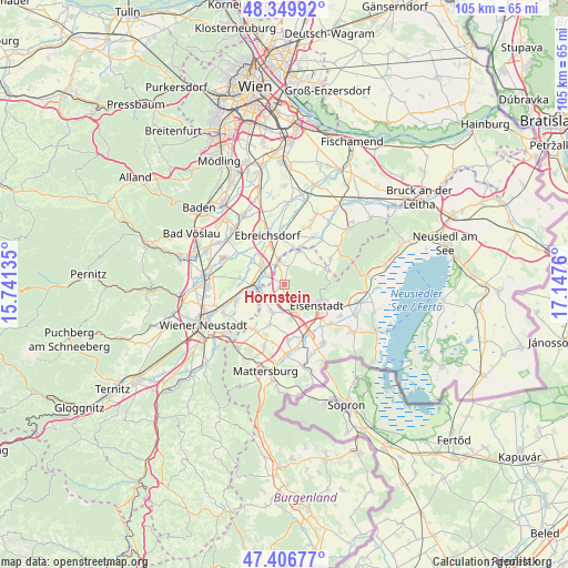
Hornstein GPS coordinates[2]
47° 52' 49.764" North, 16° 26' 40.092" East
| Map corner | latitude | longitude |
|---|---|---|
| Upper-left | 48.34992°, | 15.74135° |
| Center: | 47.88049°, | 16.44447° |
| Lower-right: | 47.40677°, | 17.1476° |
| Map W x H: | 104.9×104.9 km | = 65.2×65.2mi |
| max Lat: | 48.98333° ⇑39.8% North |
| Hornstein: | 47.88049° |
| min Lat: | ⇓60.2% South 46.48841° |
| min Long | Hornstein | max Long |
| 9.57802° | 16.44447° | 17.1° |
| W 92.5%⇐ | ⇒7.5% E |
Elevation
Elevation of Hornstein is 269 m = 883 ft, and this is 236.5 m = 776 ft below average elevation for this country.
| Max E: |
2140 m = 7021 ft | 81.2% |
| Avg. | 505.5 m = 1658 ft | |
| Hornstein | 269 m = 883 ft | |
Min E: |
118 m = 387 ft | 18.8% |
See also: Austria elevation on elevation.city.
Geographical zone
Hornstein is located in North temperate zone (between Tropic of Cancer and the Arctic Circle). Distance of this North polar circle is 2077.4 km =1290.8 mi to North.| Distance of | km | miles | from Hornstein |
|---|---|---|---|
| North Pole | 4683.3 | 2910.1 | to North |
| Arctic Circle | 2077.4 | 1290.8 | to North |
| Tropic Cancer | 2717.9 | 1688.8 | to South |
| Equator | 5323.8 | 3308.1 | to South |


Nearby cities:
15 places around Hornstein: (largest is in red/bold)
• Deutschbrodersdorf
7.2 km =4.5 mi,  15°
15°
• Ebenfurth
5.8 km =3.6 mi,  266°
266°
• Eisenstadt
7 km =4.3 mi,  123°
123°
• Grosshöflein
5.6 km =3.5 mi,  151°
151°
• Kleinhöflein im Burgenland
6.2 km =3.9 mi,  134°
134°
• Landegg
4 km =2.5 mi,  303°
303°
• Leithaprodersdorf
6.4 km =4 mi, 23°
• Loretto
6.7 km =4.2 mi,  54°
54°
• Müllendorf
4.8 km =3 mi,  163°
163°
• Neufeld an der Leitha
5.2 km =3.2 mi,  251°
251°
• Pottendorf
5 km =3.1 mi, 295°
• Steinbrunn
5.6 km =3.5 mi,  201°
201°
• Wampersdorf
4.5 km =2.8 mi,  332°
332°
• Wimpassing an der Leitha
4.1 km =2.5 mi,  348°
348°
• Zillingdorf-Bergwerk
6.2 km =3.9 mi,  229°
229°
Sources, notices
• [Note1] Compared only with cities in Austria existing in our database
• [Src1] Map data: © OpenStreetMap contributors (CC-BY-SA)
• [Src2] Other city data from geonames.org with taken over terms of usage.
• [Src3] Geographical zone / Annual Mean Temperature by Robert A. Rohde @ Wikipedia
