Lech geodata
Lech (Vorarlberg) is a seat of a third-order administrative division; located in Austria in Europe/Vienna (GMT+2) time zone. With population of 1,568 people, there are 799 cities with bigger population in this country. Compared to other cities in Austria, 71.8% of cities are located further ↑North; 96.7% of cities are located further →East and 99.4% of cities have lower elevation than Lech. Note1


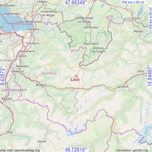
Lech GPS coordinates[2]
47° 12' 28.692" North, 10° 8' 30.624" East
| Map corner | latitude | longitude |
|---|---|---|
| Upper-left | 47.68348°, | 9.43872° |
| Center: | 47.20797°, | 10.14184° |
| Lower-right: | 46.72816°, | 10.84497° |
| Map W x H: | 106.2×106.2 km | = 66×66mi |
| max Lat: | 48.98333° ⇑71.8% North |
| Lech: | 47.20797° |
| min Lat: | ⇓28.2% South 46.48841° |
| min Long | Lech | max Long |
| 9.57802° | 10.14184° | 17.1° |
| W 3.3%⇐ | ⇒96.7% E |
Elevation
Elevation of Lech is 1442 m = 4731 ft, and this is 936.5 m = 3073 ft above average elevation for this country.
| Max E: |
2140 m = 7021 ft | 0.59999999999999% |
| Lech | 1442 m 4731 ft | |
| Avg. | 505.5 m = 1658 ft | |
Min E: |
118 m = 387 ft | 99.4% |
See also: Austria elevation on elevation.city.
Geographical zone
Lech is located in North temperate zone (between Tropic of Cancer and the Arctic Circle). Distance of this North polar circle is 2152.1 km =1337.3 mi to North.| Distance of | km | miles | from Lech |
|---|---|---|---|
| North Pole | 4758 | 2956.5 | to North |
| Arctic Circle | 2152.1 | 1337.3 | to North |
| Tropic Cancer | 2643.1 | 1642.3 | to South |
| Equator | 5249 | 3261.6 | to South |


Nearby cities:
15 places around Lech: (largest is in red/bold)
• Dalaas
14.7 km =9.1 mi,  230°
230°
• Hirschegg
15.7 km =9.8 mi,  8°
8°
• Holzgau
16.4 km =10.2 mi,  69°
69°
• Klösterle
9.4 km =5.8 mi,  208°
208°
• Mittelberg
16.1 km =10 mi, 8°
• Pettneu
16.3 km =10.1 mi,  115°
115°
• Rehmen
16.7 km =10.4 mi,  319°
319°
• Riezlern
17 km =10.6 mi, 11°
• Sankt Jakob
13.6 km =8.5 mi, 123°
• Schoppernau
14.9 km =9.3 mi, 320°
• Schröcken
6.7 km =4.2 mi,  325°
325°
• St Anton am Arlberg
12.8 km =8 mi,  134°
134°
• Steeg
12.2 km =7.6 mi, 70°
• Wald am Arlberg
11.7 km =7.3 mi,  224°
224°
• Warth
5.6 km =3.5 mi,  33°
33°
Sources, notices
• [Note1] Compared only with cities in Austria existing in our database
• [Src1] Map data: © OpenStreetMap contributors (CC-BY-SA)
• [Src2] Other city data from geonames.org with taken over terms of usage.
• [Src3] Geographical zone / Annual Mean Temperature by Robert A. Rohde @ Wikipedia
