St Anton am Arlberg geodata
St Anton am Arlberg (Tyrol) is a populated place; located in Austria in Europe/Vienna (GMT+2) time zone. With population of 1,763 people, there are 708 cities with bigger population in this country. Compared to other cities in Austria, 77.6% of cities are located further ↑North; 96.5% of cities are located further →East and 98.8% of cities have lower elevation than St Anton am Arlberg. Note1
Administrative division(s):
- Level 1: Tyrol
- Level 2: Politischer Bezirk Landeck
- Level 3: St. Anton am Arlberg


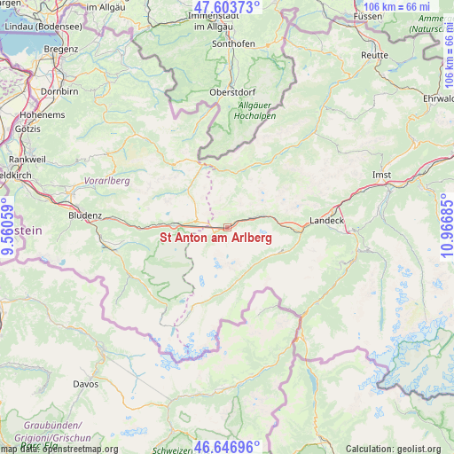
St Anton am Arlberg GPS coordinates[2]
47° 7' 39" North, 10° 15' 49.392" East
| Map corner | latitude | longitude |
|---|---|---|
| Upper-left | 47.60373°, | 9.56059° |
| Center: | 47.1275°, | 10.26372° |
| Lower-right: | 46.64696°, | 10.96685° |
| Map W x H: | 106.4×106.4 km | = 66.1×66.1mi |
| max Lat: | 48.98333° ⇑77.6% North |
| St Anton am Arlberg: | 47.1275° |
| min Lat: | ⇓22.4% South 46.48841° |
| min Long | St Anton am Arl | max Long |
| 9.57802° | 10.26372° | 17.1° |
| W 3.5%⇐ | ⇒96.5% E |
Elevation
Elevation of St Anton am Arlberg is 1307 m = 4288 ft, and this is 801.5 m = 2630 ft above average elevation for this country.
| Max E: |
2140 m = 7021 ft | 1.2% |
| St Anton am Arlberg | 1307 m 4288 ft | |
| Avg. | 505.5 m = 1658 ft | |
Min E: |
118 m = 387 ft | 98.8% |
See also: Austria elevation on elevation.city.
Geographical zone
St Anton am Arlberg is located in North temperate zone (between Tropic of Cancer and the Arctic Circle). Distance of this North polar circle is 2161.1 km =1342.8 mi to North.| Distance of | km | miles | from St Anton am Arlberg |
|---|---|---|---|
| North Pole | 4767 | 2962.1 | to North |
| Arctic Circle | 2161.1 | 1342.8 | to North |
| Tropic Cancer | 2634.2 | 1636.8 | to South |
| Equator | 5240.1 | 3256 | to South |


Nearby cities:
15 places around St Anton am Arlberg: (largest is in red/bold)
• Flirsch
10.6 km =6.6 mi,  76°
76°
• Holzgau
16 km =9.9 mi,  22°
22°
• Ischgl
13 km =8.1 mi,  170°
170°
• Kappl
11.3 km =7 mi,  126°
126°
• Klösterle
13.7 km =8.5 mi,  272°
272°
• Lech
12.8 km =8 mi,  314°
314°
• Pettneu
5.9 km =3.7 mi,  69°
69°
• Pians
18.8 km =11.7 mi,  87°
87°
• Sankt Jakob
2.6 km =1.6 mi,  54°
54°
• See
16.1 km =10 mi,  107°
107°
• Steeg
13.2 km =8.2 mi,  10°
10°
• Strengen
15 km =9.3 mi, 90°
• Tobadill
18.9 km =11.7 mi, 90°
• Wald am Arlberg
17.4 km =10.8 mi, 272°
• Warth
14.9 km =9.3 mi,  335°
335°
In other languages:
- In German: St. Anton am Arlberg
- In Russian: Санкт-Антон-ам-Арльберг
- In Chinese: 阿尔山麓圣安东
Sources, notices
• [Note1] Compared only with cities in Austria existing in our database
• [Src1] Map data: © OpenStreetMap contributors (CC-BY-SA)
• [Src2] Other city data from geonames.org with taken over terms of usage.
• [Src3] Geographical zone / Annual Mean Temperature by Robert A. Rohde @ Wikipedia
