Saxen geodata
Saxen (Upper Austria) is a populated place; located in Austria in Europe/Vienna (GMT+2) time zone. With population of 726 people, there are 1785 cities with bigger population in this country. Compared to other cities in Austria, 79.9% of cities are located further ↓South; 51.2% of cities are located further ←West and 85.8% of cities have higher elevation than Saxen. Note1


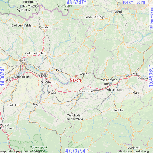
Saxen GPS coordinates[2]
48° 12' 29.736" North, 14° 47' 25.872" East
| Map corner | latitude | longitude |
|---|---|---|
| Upper-left | 48.6747°, | 14.0874° |
| Center: | 48.20826°, | 14.79052° |
| Lower-right: | 47.73754°, | 15.49365° |
| Map W x H: | 104.2×104.2 km | = 64.7×64.7mi |
| max Lat: | 48.98333° ⇑20.1% North |
| Saxen: | 48.20826° |
| min Lat: | ⇓79.9% South 46.48841° |
| min Long | Saxen | max Long |
| 9.57802° | 14.79052° | 17.1° |
| W 51.2%⇐ | ⇒48.8% E |
Elevation
Elevation of Saxen is 243 m = 797 ft, and this is 262.5 m = 861 ft below average elevation for this country.
| Max E: |
2140 m = 7021 ft | 85.8% |
| Avg. | 505.5 m = 1658 ft | |
| Saxen | 243 m = 797 ft | |
Min E: |
118 m = 387 ft | 14.2% |
See also: Austria elevation on elevation.city.
Geographical zone
Saxen is located in North temperate zone (between Tropic of Cancer and the Arctic Circle). Distance of this North polar circle is 2040.9 km =1268.2 mi to North.| Distance of | km | miles | from Saxen |
|---|---|---|---|
| North Pole | 4646.8 | 2887.4 | to North |
| Arctic Circle | 2040.9 | 1268.2 | to North |
| Tropic Cancer | 2754.3 | 1711.4 | to South |
| Equator | 5360.3 | 3330.7 | to South |


Nearby cities:
15 places around Saxen: (largest is in red/bold)
• Arbing
6.9 km =4.3 mi,  289°
289°
• Ardagger Markt
5 km =3.1 mi,  157°
157°
• Ardagger Stift
7.2 km =4.5 mi,  153°
153°
• Bad Kreuzen
6.7 km =4.2 mi,  10°
10°
• Baumgartenberg
3.5 km =2.2 mi,  270°
270°
• Grein
5.5 km =3.4 mi,  65°
65°
• Kollmitzberg
6.4 km =4 mi,  136°
136°
• Mitterkirchen im Machland
7.4 km =4.6 mi,  252°
252°
• Münzbach
8.9 km =5.5 mi,  317°
317°
• Neustadtl-Markt
8.4 km =5.2 mi,  101°
101°
• Oed
7.4 km =4.6 mi,  111°
111°
• Stephanshart
6.8 km =4.2 mi, 163°
• Viehdorf
9.9 km =6.2 mi,  130°
130°
• Wallsee
7.2 km =4.5 mi,  229°
229°
• Zeillern
8.8 km =5.5 mi,  171°
171°
Sources, notices
• [Note1] Compared only with cities in Austria existing in our database
• [Src1] Map data: © OpenStreetMap contributors (CC-BY-SA)
• [Src2] Other city data from geonames.org with taken over terms of usage.
• [Src3] Geographical zone / Annual Mean Temperature by Robert A. Rohde @ Wikipedia
