Kemeten geodata
Kemeten (Burgenland) is a seat of a third-order administrative division; located in Austria in Europe/Vienna (GMT+2) time zone. With population of 1,493 people, there are 844 cities with bigger population in this country. Compared to other cities in Austria, 69.4% of cities are located further ↑North; 84.8% of cities are located further ←West and 76.1% of cities have higher elevation than Kemeten. Note1
Administrative division(s):
- Level 1: Burgenland
- Level 2: Politischer Bezirk Oberwart
- Level 3: Kemeten


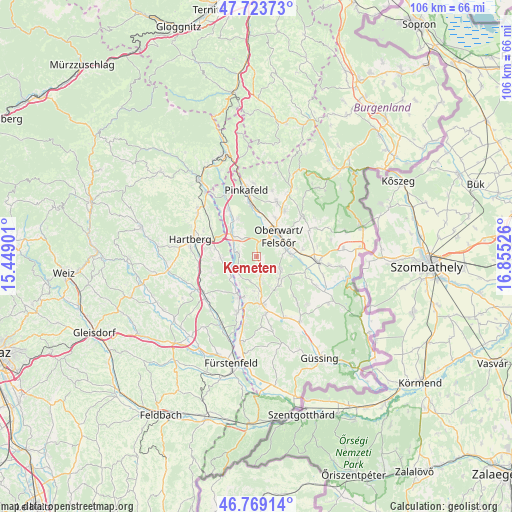
Kemeten GPS coordinates[2]
47° 14' 54.924" North, 16° 9' 7.668" East
| Map corner | latitude | longitude |
|---|---|---|
| Upper-left | 47.72373°, | 15.44901° |
| Center: | 47.24859°, | 16.15213° |
| Lower-right: | 46.76914°, | 16.85526° |
| Map W x H: | 106.1×106.1 km | = 65.9×65.9mi |
| max Lat: | 48.98333° ⇑69.4% North |
| Kemeten: | 47.24859° |
| min Lat: | ⇓30.6% South 46.48841° |
| min Long | Kemeten | max Long |
| 9.57802° | 16.15213° | 17.1° |
| W 84.8%⇐ | ⇒15.2% E |
Elevation
Elevation of Kemeten is 296 m = 971 ft, and this is 209.5 m = 687 ft below average elevation for this country.
| Max E: |
2140 m = 7021 ft | 76.1% |
| Avg. | 505.5 m = 1658 ft | |
| Kemeten | 296 m = 971 ft | |
Min E: |
118 m = 387 ft | 23.9% |
See also: Austria elevation on elevation.city.
Geographical zone
Kemeten is located in North temperate zone (between Tropic of Cancer and the Arctic Circle). Distance of this North polar circle is 2147.6 km =1334.5 mi to North.| Distance of | km | miles | from Kemeten |
|---|---|---|---|
| North Pole | 4753.5 | 2953.7 | to North |
| Arctic Circle | 2147.6 | 1334.5 | to North |
| Tropic Cancer | 2647.6 | 1645.1 | to South |
| Equator | 5253.6 | 3264.4 | to South |


Nearby cities:
15 places around Kemeten: (largest is in red/bold)
• Buchschachen
8.5 km =5.3 mi,  332°
332°
• Hackerberg
6 km =3.7 mi,  206°
206°
• Litzelsdorf
4.7 km =2.9 mi,  161°
161°
• Markt Allhau
6.5 km =4 mi,  306°
306°
• Oberdorf im Burgenland
6 km =3.7 mi,  126°
126°
• Oberwart
6.1 km =3.8 mi,  41°
41°
• Olbendorf
8.1 km =5 mi,  153°
153°
• Ollersdorf im Burgenland
7.3 km =4.5 mi,  171°
171°
• Rotenturm an der Pinka
7.4 km =4.6 mi,  88°
88°
• Stinatz
5.3 km =3.3 mi,  195°
195°
• Unterrohr
7.7 km =4.8 mi,  271°
271°
• Unterwart
6.1 km =3.8 mi, 88°
• Wolfau
3.9 km =2.4 mi, 272°
• Wörterberg
5.3 km =3.3 mi,  227°
227°
• Wörth an der Lafnitz
6.6 km =4.1 mi, 234°
Sources, notices
• [Note1] Compared only with cities in Austria existing in our database
• [Src1] Map data: © OpenStreetMap contributors (CC-BY-SA)
• [Src2] Other city data from geonames.org with taken over terms of usage.
• [Src3] Geographical zone / Annual Mean Temperature by Robert A. Rohde @ Wikipedia
