Unterrohr geodata
Unterrohr (Styria) is a populated place; located in Austria in Europe/Vienna (GMT+2) time zone. With population of 878 people, there are 1471 cities with bigger population in this country. Compared to other cities in Austria, 69.4% of cities are located further ↑North; 81.5% of cities are located further ←West and 67.1% of cities have higher elevation than Unterrohr. Note1
Administrative division(s):
- Level 1: Styria
- Level 2: Politischer Bezirk Hartberg-Fürstenfeld
- Level 3: Rohr bei Hartberg


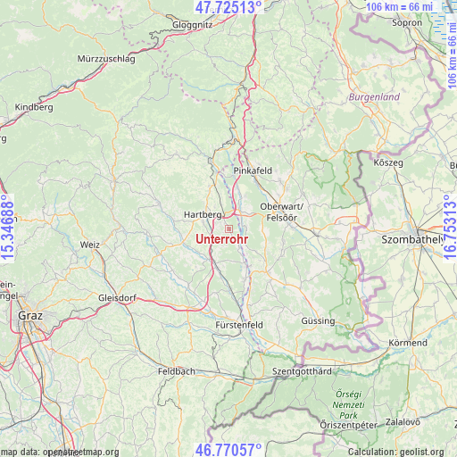
Unterrohr GPS coordinates[2]
47° 15' 0" North, 16° 3' 0" East
| Map corner | latitude | longitude |
|---|---|---|
| Upper-left | 47.72513°, | 15.34688° |
| Center: | 47.25°, | 16.05° |
| Lower-right: | 46.77057°, | 16.75313° |
| Map W x H: | 106.1×106.1 km | = 65.9×65.9mi |
| max Lat: | 48.98333° ⇑69.4% North |
| Unterrohr: | 47.25° |
| min Lat: | ⇓30.6% South 46.48841° |
| min Long | Unterrohr | max Long |
| 9.57802° | 16.05° | 17.1° |
| W 81.5%⇐ | ⇒18.5% E |
Elevation
Elevation of Unterrohr is 342 m = 1122 ft, and this is 163.5 m = 536 ft below average elevation for this country.
| Max E: |
2140 m = 7021 ft | 67.1% |
| Avg. | 505.5 m = 1658 ft | |
| Unterrohr | 342 m = 1122 ft | |
Min E: |
118 m = 387 ft | 32.9% |
See also: Austria elevation on elevation.city.
Geographical zone
Unterrohr is located in North temperate zone (between Tropic of Cancer and the Arctic Circle). Distance of this North polar circle is 2147.5 km =1334.4 mi to North.| Distance of | km | miles | from Unterrohr |
|---|---|---|---|
| North Pole | 4753.4 | 2953.6 | to North |
| Arctic Circle | 2147.5 | 1334.4 | to North |
| Tropic Cancer | 2647.8 | 1645.3 | to South |
| Equator | 5253.7 | 3264.5 | to South |


Nearby cities:
15 places around Unterrohr: (largest is in red/bold)
• Buchschachen
8.3 km =5.2 mi,  26°
26°
• Eggendorf
6.1 km =3.8 mi,  327°
327°
• Hackerberg
7.5 km =4.7 mi,  137°
137°
• Hartberg
7.3 km =4.5 mi,  300°
300°
• Kemeten
7.7 km =4.8 mi,  91°
91°
• Markt Allhau
4.5 km =2.8 mi, 34°
• Ring
7.6 km =4.7 mi, 302°
• Safenau
5.4 km =3.4 mi,  290°
290°
• Sankt Johann in der Haide
3.9 km =2.4 mi, 331°
• Sebersdorf
8.2 km =5.1 mi,  211°
211°
• Stinatz
8.2 km =5.1 mi,  129°
129°
• Unterbuch
5.2 km =3.2 mi,  240°
240°
• Wolfau
3.8 km =2.4 mi, 90°
• Wörterberg
5.3 km =3.3 mi, 134°
• Wörth an der Lafnitz
4.7 km =2.9 mi,  150°
150°
Sources, notices
• [Note1] Compared only with cities in Austria existing in our database
• [Src1] Map data: © OpenStreetMap contributors (CC-BY-SA)
• [Src2] Other city data from geonames.org with taken over terms of usage.
• [Src3] Geographical zone / Annual Mean Temperature by Robert A. Rohde @ Wikipedia
