Kautendorf geodata
Kautendorf (Lower Austria) is a populated place; located in Austria in Europe/Vienna (GMT+2) time zone. With population of 575 people, there are 2228 cities with bigger population in this country. Compared to other cities in Austria, 97.6% of cities are located further ↓South; 93.4% of cities are located further ←West and 78.3% of cities have higher elevation than Kautendorf. Note1
Administrative division(s):
- Level 1: Lower Austria
- Level 2: Politischer Bezirk Mistelbach
- Level 3: Staatz


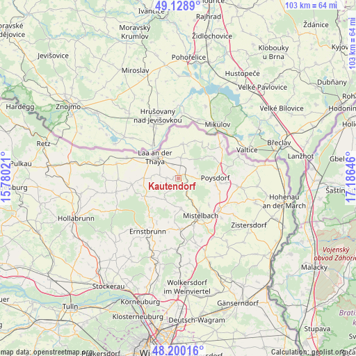
Kautendorf GPS coordinates[2]
48° 40' 0.012" North, 16° 28' 59.988" East
| Map corner | latitude | longitude |
|---|---|---|
| Upper-left | 49.1289°, | 15.78021° |
| Center: | 48.66667°, | 16.48333° |
| Lower-right: | 48.20016°, | 17.18646° |
| Map W x H: | 103.3×103.3 km | = 64.2×64.2mi |
| max Lat: | 48.98333° ⇑2.4% North |
| Kautendorf: | 48.66667° |
| min Lat: | ⇓97.6% South 46.48841° |
| min Long | Kautendorf | max Long |
| 9.57802° | 16.48333° | 17.1° |
| W 93.4%⇐ | ⇒6.6% E |
Elevation
Elevation of Kautendorf is 282 m = 925 ft, and this is 223.5 m = 733 ft below average elevation for this country.
| Max E: |
2140 m = 7021 ft | 78.3% |
| Avg. | 505.5 m = 1658 ft | |
| Kautendorf | 282 m = 925 ft | |
Min E: |
118 m = 387 ft | 21.7% |
See also: Austria elevation on elevation.city.
Geographical zone
Kautendorf is located in North temperate zone (between Tropic of Cancer and the Arctic Circle). Distance of this North polar circle is 1989.9 km =1236.5 mi to North.| Distance of | km | miles | from Kautendorf |
|---|---|---|---|
| North Pole | 4595.8 | 2855.7 | to North |
| Arctic Circle | 1989.9 | 1236.5 | to North |
| Tropic Cancer | 2805.3 | 1743.1 | to South |
| Equator | 5411.2 | 3362.4 | to South |


Nearby cities:
15 places around Kautendorf: (largest is in red/bold)
• Asparn an der Zaya
9.3 km =5.8 mi,  172°
172°
• Eibesthal
12.6 km =7.8 mi,  137°
137°
• Falkenstein
9.2 km =5.7 mi,  52°
52°
• Fallbach
5.2 km =3.2 mi,  249°
249°
• Gaubitsch
7.6 km =4.7 mi,  255°
255°
• Gnadendorf
8.3 km =5.2 mi,  227°
227°
• Hanfthal
9.3 km =5.8 mi,  293°
293°
• Laa an der Thaya
9.2 km =5.7 mi,  307°
307°
• Neudorf bei Staatz
6.1 km =3.8 mi,  5°
5°
• Ottenthal
12.6 km =7.8 mi,  33°
33°
• Poysdorf
11 km =6.8 mi,  90°
90°
• Siebenhirten
8.3 km =5.2 mi,  153°
153°
• Staatz
1.1 km =0.7 mi,  15°
15°
• Unterstinkenbrunn
10.1 km =6.3 mi,  270°
270°
• Wildendürnbach
10.1 km =6.3 mi, 8°
Sources, notices
• [Note1] Compared only with cities in Austria existing in our database
• [Src1] Map data: © OpenStreetMap contributors (CC-BY-SA)
• [Src2] Other city data from geonames.org with taken over terms of usage.
• [Src3] Geographical zone / Annual Mean Temperature by Robert A. Rohde @ Wikipedia
