Jadorf geodata
Jadorf (Salzburg) is a populated place; located in Austria in Europe/Vienna (GMT+2) time zone. With population of 554 people, there are 2301 cities with bigger population in this country. Compared to other cities in Austria, 51.6% of cities are located further ↓South; 80.3% of cities are located further →East and 52% of cities have lower elevation than Jadorf. Note1


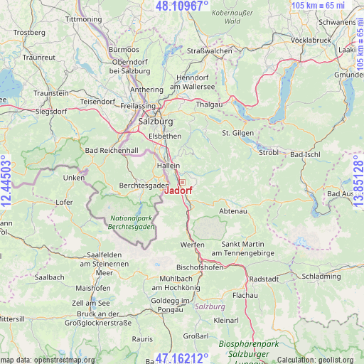
Jadorf GPS coordinates[2]
47° 38' 16.944" North, 13° 8' 53.34" East
| Map corner | latitude | longitude |
|---|---|---|
| Upper-left | 48.10967°, | 12.44503° |
| Center: | 47.63804°, | 13.14815° |
| Lower-right: | 47.16212°, | 13.85128° |
| Map W x H: | 105.4×105.4 km | = 65.5×65.5mi |
| max Lat: | 48.98333° ⇑48.4% North |
| Jadorf: | 47.63804° |
| min Lat: | ⇓51.6% South 46.48841° |
| min Long | Jadorf | max Long |
| 9.57802° | 13.14815° | 17.1° |
| W 19.7%⇐ | ⇒80.3% E |
Elevation
Elevation of Jadorf is 464 m = 1522 ft, and this is 41.5 m = 136 ft below average elevation for this country.
| Max E: |
2140 m = 7021 ft | 48% |
| Avg. | 505.5 m = 1658 ft | |
| Jadorf | 464 m = 1522 ft | |
Min E: |
118 m = 387 ft | 52% |
See also: Austria elevation on elevation.city.
Geographical zone
Jadorf is located in North temperate zone (between Tropic of Cancer and the Arctic Circle). Distance of this North polar circle is 2104.3 km =1307.6 mi to North.| Distance of | km | miles | from Jadorf |
|---|---|---|---|
| North Pole | 4710.2 | 2926.8 | to North |
| Arctic Circle | 2104.3 | 1307.6 | to North |
| Tropic Cancer | 2690.9 | 1672 | to South |
| Equator | 5296.9 | 3291.3 | to South |


Nearby cities:
15 places around Jadorf: (largest is in red/bold)
• Adnet
6.7 km =4.2 mi,  349°
349°
• Bad Dürrnberg
5.3 km =3.3 mi,  304°
304°
• Burgfried
5.4 km =3.4 mi,  329°
329°
• Garnei
1.7 km =1.1 mi,  311°
311°
• Georgenberg
0.5 km =0.3 mi,  165°
165°
• Golling an der Salzach
4.5 km =2.8 mi,  161°
161°
• Hallein
6.2 km =3.9 mi,  324°
324°
• Kellau
4.1 km =2.5 mi,  145°
145°
• Kuchl
1.3 km =0.8 mi,  191°
191°
• Obergäu
5.8 km =3.6 mi, 158°
• Oberlangenberg
3 km =1.9 mi,  94°
94°
• Taugl
4.2 km =2.6 mi,  75°
75°
• Torren
4.2 km =2.6 mi,  178°
178°
• Vigaun
3.4 km =2.1 mi,  340°
340°
• Waidach
5.7 km =3.5 mi, 352°
Sources, notices
• [Note1] Compared only with cities in Austria existing in our database
• [Src1] Map data: © OpenStreetMap contributors (CC-BY-SA)
• [Src2] Other city data from geonames.org with taken over terms of usage.
• [Src3] Geographical zone / Annual Mean Temperature by Robert A. Rohde @ Wikipedia
